FUTURE DIRECTIONS OF THE
NATIONAL CORS SYSTEM
Richard A. Snay and Neil D. Weston, National Geodetic Survey, NOAA
Reproduced from the Proceedings of the 55th Annual Meeting of the Institute of Navigation, Cambridge, MA, June 1999, pp 301-305.
|
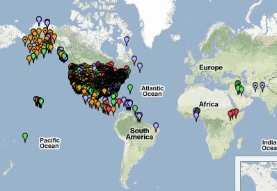
CORS COVERAGE MAP
BIOGRAPHIES
Richard A. Snay is Project Manager of the National CORS system.
He has been a geodesist with the National Geodetic Survey (NGS) since 1974.
Richard received his Ph.D. in Mathematics from Indiana University in 1972. He
previously taught at the University of Minnesota, the University of North Carolina
at Charlotte, and George Washington University. He also served as a visiting
scientist with Stutgart University and the Southern California Earthquake Center.
Richard has also developed crustal motion models to support accurate time-dependent
positioning in the United States.
Neil D. Weston is Technical Manager of the National CORS system.
He is a geodesist with NGS' Geosciences Research Division. Neil received B.S.
degrees in Physics and Biology from the University of Tampa in 1987 and his
M.S. degree in Physics from the University of South Florida in 1992. He has
served with NGS' parent agency, the National Ocean Service, since 1992. From
1992 to 1994, Neil worked on the hydrographic ship, MT MITCHELL, on various
projects including deep sea bathyometric surveys in the Atlantic, obstruction
analyses in the Gulf of Mexico, and a harbor survey in St. Thomas, VI.
|
ABSTRACT
The National Geodetic Survey (NGS) continues to enhance the
National CORS (Continuously Operating Reference Station) system, thereby improving
people's ability to apply Global Positioning System (GPS) data for positioning
points with cm-level accuracy throughout the United States and its territories.
People also use CORS data to develop geographic information systems, to monitor
crustal deformation, to determine the distribution of water vapor in the atmosphere,
to support remote sensing operations, and to determine the distribution of free
electrons in the ionosphere. NGS is steadily increasing the spatial coverage
of the National CORS system by adding an average of 3 new sites per month. In
June 1999, the system contained 156 sites. In addition, NGS plans to regularly
upgrade its user-friendly CORS information server, making CORS data and related
information (descriptive text, site positions and velocities, GPS orbits, selected
meteorological data, etc.) more readily available via the Internet. Also our
agency is:
- generating digital models of antenna-phase-center variation,
crustal motion, total electron content in the ionosphere, and geoid heights;
- supporting research to develop reduced multipath GPS
sites; and
- investigating the possibility of providing nationwide
digital maps of pertinent meteorological data for enabling more rigorous GPS
processing.
Moreover, NGS will continue to study how enhancements
to the CORS system impact positioning accuracy and its relationship with the
distance to the nearest CORS and the duration of an observing session.
|
INTRODUCTION
The National Geodetic Survey (NGS), an office of NOAA's National
Ocean Service, coordinates a network of Continuously Operating Reference Stations
(CORS) that provide GPS carrier phase and code range measurements in support
of 3-dimensional positioning activities throughout the United States and its
territories.
Surveyors, GIS/LIS professionals, engineers, scientists, and
others can apply CORS data to position points at which other GPS data have been
collected. When used in postsurvey mode, National CORS data enable positioning
accuracies that approach a few centimeters relative to the National Spatial
Reference System, both horizontally and vertically.
|
The National CORS system benefits from a multi-purpose cooperative
endeavor involving many government, academic, commercial, and private organizations.
New sites are evaluated for inclusion according to established criteria. As
of June 1999, the system contained 156 sites, and it is currently growing at
a rate of approximately 3 sites per month. This growth is expected to continue
over at least the next few years, as the U.S. Department of Transportation is
installing about 65 additional CORS as part of the Nationwide Differential GPS
(NDGPS) service. In addition to serving as CORS, these NDGPS sites will broadcast
"correctors" to the GPS signal, which enable navigation and real-time positioning
at the few meter level. Also, NOAA's Forecast System Laboratory is utilizing
existing and future NDGPS/CORS sites equipped with surface meteorological (Sfc.
Met) sensors, and installing approximately 40 of its own CORS, to evaluate the
impact of precipitable water vapor data derived from GPS signal delays on weather
forecast accuracy. Finally, government agencies at all levels, academic institutions,
and other organizations are installing additional GPS base stations for various
other applications. Many of these are expected to join the National CORS system.
Data from all CORS are transmitted hourly or daily to NGS
headquarters in Silver Spring, MD where these data are
converted into RINEX (version 2) format and made
publically available via the Internet. In particular, people
may download CORS data either via anonymous ftp (file
transfer protocol) using the address
ftp://www.ngs.noaa.gov/cors/
or through the World Wide
Web using the address
http://www.ngs.noaa.gov/CORS/.
Furthermore, people may pose CORS-related questions to
NGS here.
CORS INFORMATION SERVER
In November 1998, NGS introduced a web-based utility to provide
CORS users with customized datasets. Known as
UFCORS,
this user-friendly CORS
information server is designed to save people from tedious data manipulation
and file management tasks. In particular, UFCORS allows people to:
- request CORS data for an exact time interval specified
in international or local time,
- choose a sampling rate for the requested data, and
- specify how the data should be compressed to speed
data transfer to the user.
NGS plans to regularly upgrade UFCORS. During the summer of
1999 the agency will release a new version that will allow people to:
- receive the requested information within a few minutes,
- obtain pertinent descriptive text (log files and data
sheets) for CORS sites,
- retrieve adopted NAD 83 and ITRF positions and velocities
for CORS sites,
- obtain meteorological data for those CORS that have
Sfc. Met sensors, and
- retrieve both the highly accurate GPS satellite orbits
produced by the International GPS Service (IGS) and the "broadcast" GPS orbits.
A future version of UFCORS will feature an interactive map
of the CORS network with links to pertinent information
about these sites and their data so that people may easily
identify the CORS data most suitable for their needs.
DIGITAL MODELS
To obtain extremely accurate positions, GPS users need
various auxiliary sources of information, as embodied in
digital models for antenna-phase-center variation, crustal
motion, "space weather", and geoid heights. In each case,
NGS is striving to provide people with the most accurate
models available.
For modeling antenna-phase-center variation, NGS has
calibrated several copies of each geodetic-quality antenna
type. The resulting model for a particular antenna type
describes how the location where the antenna receives
incoming GPS signals varies as a function of the frequency
of the signal and the elevation angle to the corresponding
GPS satellite. Models for about 60 antenna types may be
found at the web site
http://geodesy.noaa.gov/ANTCAL/
.
Failure to account for antenna-phase-center variation can
lead to errors of up to 10 cm in height when processing GPS
data for a baseline involving two different antenna types.
For crustal motion, NGS has incorporated models derived
by various researchers into a software package called HTDP
(Horizontal Time-Dependent Positioning) [Snay, 1999].
This software may be used to predict velocities at any
location in the United States as needed to relate positions
derived for different times. In the coterminous United
States, points typically move at speeds ranging between 10
and 20 mm/yr when referred to ITRF96 or to WGS 84
(G873). This motion, which is due to plate tectonics, is
generally not a factor when points are referred to NAD 83.
For all three of these reference frames, however, significant
motions occur in California, Oregon, Washington, Alaska,
and Hawaii. Recently, NGS created a web page which
enables people to use HTDP interactively to predict
velocities for individual points. People may access this
page from http://www.ngs.noaa.gov by clicking on
"Geodetic Tool Kit" and then clicking on
"HTDP".
The ionosphere is a level of the upper atmosphere where a
significant number of electrons have been removed from
atoms and molecules to form free electrons and positively
charged ions. Such ionization is commonly caused, for
instance, by extreme ultraviolet light from the sun
separating a single electron from an oxygen atom. The level
of ionization varies as a function of both time and location;
hence, the term "space weather" has been applied to this
phenomenon.
The presence of free electrons in the ionosphere slows the
speed of GPS radio signals traveling through it in a manner
that is frequency dependent. As a consequence, the known
differential effect on the two GPS frequencies can be used
to monitor the total electron content of the ionosphere.
Indeed, NGS scientists are using data from the National
CORS system to construct contour maps of total electron
content over the coterminous United States every 30
minutes. This quantity is routinely used to monitor
ionospheric disturbances caused by geomagnetic storms and
is a component of space weather forecasts and warnings.
Each contour map displays total electron content (TEC) as
a function of geographic location for a given time. TEC
(measured in units of 1016 electrons per m2) quantifies the
number of electrons for a given line of sight. Thus, the
plotted TEC values are associated with vertical lines of sight
from terrestrial points.
NGS plans to provide digital models corresponding to these
maps so that people who use single frequency GPS
receivers may apply appropriate corrections to their data.
GPS data can be readily processed to obtain ellipsoidal
height, h, the height above or below a simple ellipsoid
model of the Earth. Geodetic leveling, however, gives rise
to orthometric height, H, often known as the height above
or below mean sea level. Orthometric heights are found on
topographic maps as well as stored in innumerable digital
and paper datasets as they govern how water flows. To
transform between these height systems, one requires the
geoid height, N, to apply the equation: h = H + N. In and
around the coterminous United States, geoid heights range
from a low of -51.6 meters in the Atlantic Ocean to a high
of -7.2 meters in the Rocky Mountains. NGS provides a
high-resolution model, called GEOID96, for determining
geoid heights and other geoid-related products [Smith and
Milbert, 1999]. For details, see the web site
http://www.ngs.noaa.gov/GEOID/ .
The agency expects to release an improved model,
GEOID99,
sometime in the fall of 1999.
REDUCING MULTIPATH
NGS' Geosciences Research Division is planning to explore
the suppression of multipath effects on GPS signals through
the use of an absorbing plane under the antenna. The plane
will consist of commercially available non-reflecting
material arranged in about an 8-foot square around the
antenna. The edge of the material will be tapered to provide
an impedance match to the surrounding surface and thereby
reduce reflection's other edge effects. NGS plans to use
differential phase measurements between antennas with and
without the absorbing medium to explore the effectiveness
of the absorbing plane.
Experiments with absorbing planes have been done in the
past, but the results have not been published and are
therefore difficult to evaluate. NGS intends to find out
whether the performance of modern choke-ring type
antennas and others can be significantly enhanced with
these techniques. NGS also plans to investigate the
effectiveness of various different types of absorbing media.
The agency will evaluate whether these techniques can be
made portable and suitable for field use, or suitable for
permanent fixed stations, or will remain a largely
experimental technique.
WEATHER DATA
A significant obstacle to obtaining accurate GPS results is
due to refraction of the GPS signal by water vapor in the atmosphere. Most of
the water vapor is located in the electrically neutral region of the lower atmosphere
called the troposphere where most of the "weather" occurs. If unaccounted for,
total tropospheric refraction, which has a wet and dry component, can delay
the GPS signal by about 2.5 meters at sea level for a satellite at zenith. Bevis
and others [1992] showed that the wet component of the zenith delay (ZWD) is
nearly proportional to the total quantity of precipitable water vapor (PWV)
in a column of air directly above the GPS antenna. As a rule of thumb,
ZWD ~ 6.4 PWV .
NOAA weather prediction models provide reasonably
accurate descriptions of the temperature, pressure, and
moisture fields over the coterminous United States every
hour, with predictions out to 3 and 12 hours. NGS intends
to supply relevant atmospheric data to GPS users,
distinguishing between observation analyses and forecasts,
to enable users to compute more accurate positions in near
real-time.
ACCURACY VERSUS LENGTH & TIME
NGS is studying how GPS positioning accuracy depends
on the distance to the nearest CORS site and on the length of time of the observing
session. Several GPS datasets were processed for 11 baselines distributed around
the United States with baseline lengths ranging from 26 km to 300 km. Moreover,
observing times ranged from 4 to 24 hours. Additional tests are now being performed
for shorter observing times. Preliminary results indicate that:
COMMENTS
The National CORS system is rapidly becoming the
preferred method for accurate 3D positioning in the United
States. Unlike traditional geodetic control points, users
need not set up instruments at the CORS; they need only to
download pertinent data via the Internet. The web-based
utility, UFCORS, has made such downloads easy. Although
distances to CORS currently seem excessive, this
disadvantage may be negated by using "precise" GPS orbits.
As part of the CORS project, NGS is working with
scientists around the world to develop digital models and
techniques that will enable GPS users to determine accurate
positions economically and in a timely manner.
ACKNOWLEDGMENTS
We express our gratitude to the following people who are
contributing significantly to the activities discussed in this
paper: Gordon W. Adams, Stanley G. Benjamin, Everett
Dutton, Mark C. Eckl, Seth I. Gutman, Donald E. Haw,
Stephen A. Hilla, Gerald L. Mader, John D. Marshall,
Dennis G. Milbert, Frank W. Mowry, Steven Musman,
Douglas S. Robertson, Mark S. Schenewerk, Charles R.
Schwarz, and Dru A. Smith.
REFERENCES
Bevis, M, S Businger, TA Herring, C Rocken, R Anthes,
and RH Ware (1992) GPS Meteorology: Remote sensing of
atmospheric water vapor using the Global Positioning
System. Journal of Geophysical Research, Vol D14, pp
15,787-15,801.
Smith, DA, and DG Milbert (1999) The GEOID96 high
resolution geoid height model for the United States. Journal
of Geodesy, Vol 73, pp 219-236.
Snay, RA (1999) Using the HTDP software to transform
spatial coordinates across time and between reference
frames. Surveying and Land Information Systems, Vol 59,
pp 15-25.