Geodesy for the Layman was originally published by the United States Air Force in 1959. Last revised in 1984, it is now maintained by the National Imagery and Mapping Agency, and is available from their Geodesy and Geophysics publications we page.
BUILDING 56 U S NAVAL OBSERVATORY DMA TR 80-003
WASHINGTON D C 20305
16 March 1984
FOR THE DIRECTOR:

                                           VIRGIL J JOHNSON
                                           Captain, USN
                                           Chief of Staff
The Defense Mapping Agency provides mapping, charting and geodetic support to the Secretary of Defense, the Joint Chiefs of Staff, the military departments and other Department of Defense components. The support includes production and worldwide distribution of maps, charts, precise positioning data and digital data for strategic and tactical military operations and weapon systems. The Defense Mapping Agency also provides nautical charts and marine navigational data for the worldwide merchant marine and private yachtsmen.
The agency is under the direction and control of the Under Secretary of Defense for Research and Engineering and its director is responsible to the Joint Chiefs of Staff for operational matters.
The Defense Mapping Agency maintains close liaison with civilian agencies of the U.S. government which are engaged in mapping, charting and geodetic (MC&G) activities. To further the advances in MC&G, the agency works with various national and international scientific and operational organizations.
GEODESY FOR THE LAYMAN, first published in 1959, was written by Lt Col Richard K. Burkard (retired). Since that time and through this, its fourth revision, a host of authors have revised and supplemented the original work. The publication attempts to develop an appreciation of the scope of geodesy and to generate some understanding of the problems encountered in the science. The basic principles are presented through discussions of various geodetic topics such as: ellipsoids, geoid, horizontal surveying, leveling, geodetic datums and gravity. This edition provides a revised chapter on Satellite Geodesy to present the results of growth in this field and a new chapter on Other Developments in Geodesy to present the effect of recent applications of new technology to Geodesy. Also, the chapter on the World Geodetic System has been extensively revised and placed last in keeping with the World Geodetic System's role as the end product of much of the endeavor described in the preceding chapters.
What is geodesy? Who needs it and why? These are some of the questions asked by many people. Actually, geodesy is nothing new having been around for centuries. Webster defines geodesy as "that branch of applied mathematics which determines by observation and measurement the exact positions of points and the figures and areas of large portions of the earth's surface, the shape and size of the earth, and the variations of terrestrial gravity." It is a specialized application of several familiar facets of basic mathematical and physical concepts. In practice, geodesy uses the principles of mathematics, astronomy and physics, and applies them within the capabilities of modern engineering and technology. A thorough study of the science of geodesy is not a simple undertaking. However, it is possible to gain an understanding of the historical development, a general knowledge of the methods and techniques of the science, and the way geodesy is being used to solve some Department of Defense (DoD) problems.
In the past, military geodesy was largely involved with the practical aspect of the determination of exact positions of points on the earth's surface for mapping or artillery control purposes while the determination of the precise size and shape of the earth was a purely scientific role. However, modern requirements for distance and direction require both the practical and scientific applications of the science to provide the answers to problems in such fields as satellite tracking, global navigation and defensive missile operations.
Man has been concerned about the earth on which he lives for many centuries. During very early times this concern was limited, naturally, to the immediate vicinity of his home; later it expanded to the distance of markets or exchange places; and finally, with the development of means of transportation man became interested in his whole world. Much of this early "world interest" was evidenced by speculation concerning the size, shape, and composition of the earth.
The early Greeks, in their speculation and theorizing, ranged from the flat disc advocated by Homer to Pythagoras' spherical figure-an idea supported one hundred years later by Aristotle. Pythagoras was a mathematician and to him the most perfect figure was a sphere. He reasoned that the gods would create a perfect figure and therefore the earth was created to be spherical in shape. Anaximenes, an early Greek scientist, believed strongly that the earth was rectangular in shape.
Since the spherical shape was the most widely supported during the Greek Era, efforts to determine its size followed. Plato determined the circumference of the earth to be 40,000 miles while Archimedes estimated 30,000 miles. Plato's figure was a guess and Archimedes' a more conservative approximation. Meanwhile, in Egypt, a Greek scholar and philosopher, Eratosthenes, set out to make more explicit measurements.
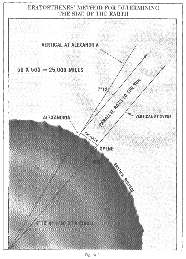
He had observed that on the day of the summer solstice, the midday sun shone to the bottom of a well in the town of Syene (Aswan). Figure 1. At the same time, he observed the sun was not directly overhead at Alexandria; instead, it cast a shadow with the vertical equal to 1/50th of a circle (7° 12'). To these observations, Eratosthenes applied certain "known" facts (1) that on the day of the summer solstice, the midday sun was directly over the line of the summer Tropic Zone (Tropic of Cancer)-Syene was therefore concluded to be on this line; (2) the linear distance between Alexandria and Syene was 500 miles; (3) Alexandria and Syene lay on a direct northsouth line.
FIGURE 1 ERATOSTHENES' METHOD FOR DETERMINING THE SIZE OF THE EARTH
From these observations and "known" facts, Eratosthenes concluded that, since the angular deviation of the sun from the vertical at Alexandria was also the angle of the subtended arc, the linear distance between Alexandria and Syene was 1/50 of the circumference of the earth or 50 x 500 = 25,000 miles. A currently accepted value for the earth's circumference at the Equator is 24,901 miles, based upon the equatorial radius of the World Geodetic System (Chapter VIII). The actual unit of measure used by Eratosthenes was called the "stadia." No one knows for sure what the stadia that he used is in today's units. The measurements given above in miles were derived using one stadia equal to one-tenth statute mile.
It is remarkable that such accuracy was obtained in view of the fact that most of the "known" facts and his observations were incorrect: (1) although it is true that the sun at noon is directly overhead at the Tropic of Cancer on the day of the summer solstice, it was erroneously concluded that Syene lay on the line. Actually, Syene is 37 miles to the north; (2) the true distance between Alexandria and Syene is 453 miles and not 500; (3) Syene lies 3° 30' east of the meridian of Alexandria; (4) the difference of latitude between Alexandria and Syene is 7° 5' rather than 7° 12' as Eratosthenes had concluded.
Another ancient measurement of the size of the earth was made by the Greek, Posidonius. He noted that a certain star was hidden from view in most parts of Greece but that it just grazed the horizon at Rhodes. Posidonius measured the elevation of the same star at Alexandria and determined that the angle was 1/48th of circle. Assuming the distance from Alexandria to Rhodes to be 500 miles, he computed the circumference of the earth as 24,000 miles. While both his measurements were approximations when combined, one error compensated for another and he achieved a fairly accurate result.
Revising the figures of Posidonius, another Greek philosopher determined 18,000 miles as the earth's circumference. This last figure was promulgated by Ptolemy through his world maps. The maps of Ptolemy strongly influenced the cartographers of the middle ages. It is probable that Columbus, using such maps, was led to believe that Asia was only 3 or 4 thousand miles west of Europe. It was not until the 15th century that his concept of the earth's size was revised. During that period the Flemish cartographer, Mercator, made successive reductions in the size of the Mediterranean Sea and all of Europe which had the effect of increasing the size of the earth.
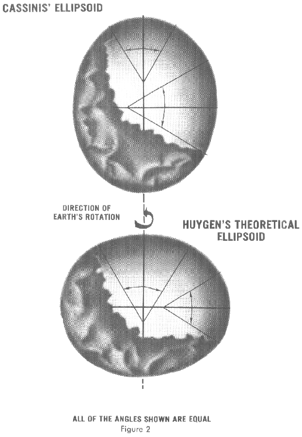
The telescope, logarithmic tables, and the method of triangulation were contributed to the science of geodesy during the 17th century. In the course of the century, the Frenchman, Picard, performed an arc measurement that is modern in some respects. He measured a base line by the aid of wooden rods, used a telescope in his angle measurements, and computed with logarithms. Cassini later continued Picard's arc northward to Dunkirk and southward to the Spanish boundary. Cassini divided the measured arc into two parts, one northward from Paris, another southward. When he computed the length of a degree from both chains, he found that the length of one degree in the northern part of the chain was shorter than that in the southern part. Figure 2. This unexpected result could have been caused only by an egg-shaped earth or by observational errors.
FIGURE 2 CASSINIS' ELLIPSOID; HUYGEN'S THEORETICAL ELLIPSOID
The results started an intense controversy between French and English scientists. The English claimed that the earth must be flattened, as Newton and Huygens had shown theoretically, while the Frenchmen defended their own measurement and were inclined to keep the earth egg-shaped.
To settle the controversy, once and for all, the French Academy of Sciences sent a geodetic expedition to Peru in 1735 to measure the length of a meridian degree close to the Equator and another to Lapland to make a similar measurement near the Arctic Circle. The measurements conclusively proved the earth to be flattened, as Newton had forecast. Since all the computations involved in a geodetic survey are accomplished in terms of a mathematical surface (reference ellipsoid) resembling the shape of the earth, the findings were very important.
The expression "figure of the earth" has various meanings in geodesy according to the way it is used and the precision with which the earth's size and shape is to be defined. The actual topographic surface is most apparent with its variety of land forms and water areas. This is, in fact, the surface on which actual earth measurements are made. It is not suitable, however, for exact mathematical computations because the formulas which would be required to take the irregularities into account would necessitate a prohibitive amount of computations. The topographic surface is generally the concern of topographers and hydrographers.
The Pythagorean spherical concept offers a simple surface which is mathematically easy to deal with. Many astronomical and navigational computations use it as a surface representing the earth. While the sphere is a close approximation of the true figure of the earth and satisfactory for many purposes, to the geodesists interested in the measurement of long distances-spanning continents and oceans-a more exact figure is necessary. The idea of flat earth, however, is still acceptable for surveys of small areas. Plane-table surveys are made for relatively small areas and no account is taken of the curvature of the earth. A survey of a city would likely be computed as though the earth were a plane surface the size of the city. For such small areas, exact positions can be determined relative to each other without considering the size and shape of the total earth.
Ellipsoid of Revolution
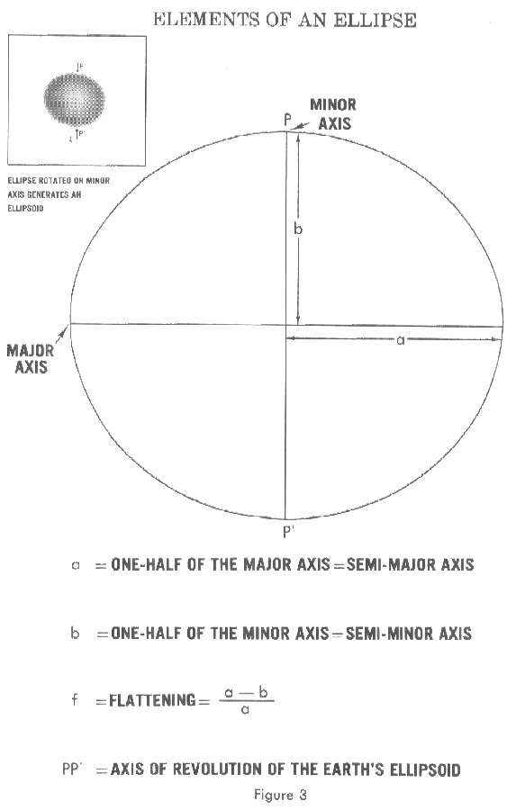
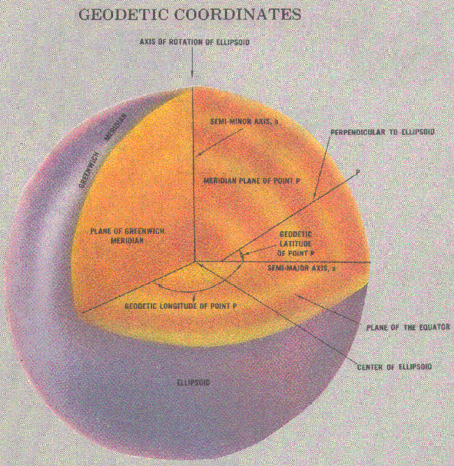
Since the earth is in fact flattened slightly at the poles and bulges somewhat at the equator, the geometrical figure used in geodesy to most nearly approximate the shape of the earth is an ellipsoid of revolution. The ellipsoid of revolution is the figure which would be obtained by rotating an ellipse about its shorter axis. Figure 3.
FIGURE 3 ELEMENTS OF AN ELLIPSE
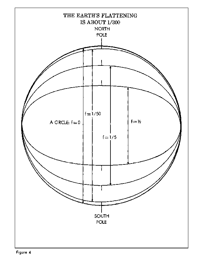
An ellipsoid of revolution is uniquely defined by specifying two dimensions. Geodesists, by convention, use the semimajor axis and flattening. The size is represented by the radius at the equator-the semimajor axis-and designated by the letter, a. The shape of the ellipsoid is given by the flattening, f, which indicates how closely an ellipsoid approaches a spherical shape. The difference between the ellipsoid of revolution representing the earth and a sphere is very small. Figure 4.
FIGURE 4 THE EARTH'S FLATTENING
The ellipsoids listed below have had utility in geodetic work and many are still in use. The older ellipsoids are named for the individual who derived them and the year of development is given. The international ellipsoid was developed by Hayford in 1910 and adopted by the International Union of Geodesy and Geophysics (IUGG) which recommended it for international use.
At the 1967 meeting of the IUGG held in Lucerne, Switzerland, the ellipsoid called GRS-67 in the listing was recommended for adoption. The new ellipsoid was not recommended to replace the International Ellipsoid (1924), but was advocated for use where a greater degree of accuracy is required. It became a part of the Geodetic Reference System 1967 which was approved and adopted at the 1971 meeting of the IUGG held in Moscow. It is used in Australia for the Australian Geodetic Datum and in South America for the South American Datum 1969.
The ellipsoid called GRS-80 (Geodetic Reference System 1980) was approved and adopted at the 1979 meeting of the IUGG held in Canberra, Australia. The ellipsoids used to define WGS 66 and WGS 72 are discussed in Chapter VIII.
| NAME | EQUATORIAL RADIUS | FLATTENING | WHERE USED |
|---|---|---|---|
| Krassowsky (1940) | 6,378,245m | 1/298.3 | Russia |
| International (1924) | 6,378,388 | 1/297 | Europe |
| Clarke (1880) | 6,378,249 | 1/293.46 | France, Africa |
| Clarke (1866) | 6,378,206 | 1/294.98 | North America |
| Bessel (1841) | 6,377,397 | 1/299.15 | Japan |
| Airy (1830) | 6,377,563 | 1/299.32 | Great Britain |
| Everest (1830) | 6,377,276 | 1/300.80 | India |
| WGS 66 (1966) | 6,378,145 | 1/298.25 | USA/DoD |
| GRS 67 (1967) | 6,378,160 | 1/298.25 | Australia | Australia
| South America | |||
| WGS 72 (1972) | 6,378,135 | 1/298.26 | USA/DoD |
| GRS 80 (1979) | 6,378,137 | 1/298.26 |
The possibility that the earth's equator is an ellipse rather than a circle and therefore that the ellipsoid is triaxial has been a matter of scientific controversy for many years. Modern technological developments have furnished new and rapid methods for data collection and since the launching of the first Russian sputnik, orbital data has been used to investigate the theory of ellipticity.
A second theory, more complicated than triaxiality, proposed that satellite orbital variations indicate additional flattening at the south pole accompanied by a bulge of the same degree at the north pole. It is also contended that the northern middle latitudes were slightly flattened and the southern middle latitudes bulged in a similar amount. This concept suggested a slight pearshaped earth and was the subject of much public discussion. Modern geodesy tends to retain the ellipsoid of revolution and treat triaxiality and pear shape as a part of the geoid separation (to be discussed later).
Geoid
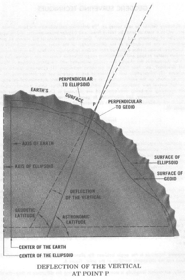
It was stated earlier that measurements are made on the apparent or topographic surface of the earth and it has just been explained that computations are performed on an ellipsoid. One other surface is involved in geodetic measurement-the geoid. In geodetic surveying, the computation of the geodetic coordinates of points is performed on an ellipsoid which closely approximates the size and shape of the earth in the area of the survey. The actual measurements made on the surface of the earth with certain instruments are referred to the geoid, as explained below. The ellipsoid is a mathematically defined regular surface with specific dimensions. The geoid, on the other hand, coincides with that surface to which the oceans would conform over the entire earth if free to adjust to the combined effect of the earth's mass attraction and the centrifugal force of the earth's rotation. As a result of the uneven distribution of the earth's mass, the geoidal surface is irregular and, since the ellipsoid is a regular surface, the two will not coincide. The separations are referred to as geoid undulations, geoid heights, or geoid separations.
The geoid is a surface along which the gravity potential is everywhere equal and to which the direction of gravity is always perpendicular. The later is particularly significant because optical instruments containing leveling devices are commonly used to make geodetic measurements. When properly adjusted, the vertical axis of the instrument coincides with the direction of gravity and is, therefore, perpendicular to the geoid. The angle between the plumb line which is perpendicular to the geoid (sometimes called "the vertical") and the perpendicular to the ellipsoid (sometimes called "the normal") is defined as the deflection of the vertical. Figure 5 shows the north-south component of the deflection of the vertical.
FIGURE 5 DEFLECTION OF THE VERTICAL
The dictionary defines the verb survey as, "To determine and delineate the form, extent, position, etc., of, as a tract of land, by taking linear and angular measurements, and by applying the principles of geometry and trigonometry." One of the functions of the science of geodesy was defined in the Introduction as the determination of the exact positions of points on the earth's surface. It was further explained that modern technology has brought with it a positioning problem insofar as long and intermediate range defensive weapons are involved. The operations to be discussed in this chapter are closely associated with the entire problem of How far? In what direction?, etc. Four traditional surveying techniques (1) astronomic positioning, (2) triangulation, (3) trilateration, and (4) traverse are in general use for determining the exact positions of points on the earth's surface. In recent years, modern technological developments have added several new methods utilizing artificial earth satellites. Other methods relevant to geodetic surveying are being developed and are discussed in Chapter VII. Another field of endeavor, Photogrammetry, has contributed to geodetic surveying for many years but is not discussed in this publication except for the observation of satellites by cameras which is included in Chapter VI.
Astronomic Position Determination
The position of a point can be obtained directly by observing the stars. Astronomic positioning is the oldest positioning method. It has been used for many years by mariners and, more recently, by airmen for navigational purposes. Explorers have often used the astronomic method to locate themselves in uncharted areas. Geodesists must use astronomic positions along with other types of survey data such as triangulation and trilateration to establish precise positions. Single astronomic positions not interconnected by geodetic surveys cannot be related to each other with sufficient accuracy for the computation of distance and direction between points.
As the name implies, astronomic positions are obtained by measuring the angles between the plumb line at the point and a star or series of stars and recording the precise time at which the measurements are made. After combining the data with information obtained from star catalogues, the direction of the plumb line (zenith direction) is computed.
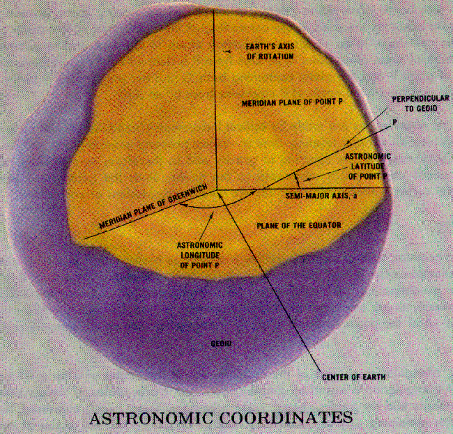
While geodesists use elaborate and very precise techniques for determining astronomic latitude, the simplest method, in the northern hemisphere, is to measure the elevation of Polaris above the horizon of the observer. For the purposes of this publication, astronomic latitude is defined as the angle between the perpendicular to the geoid and the plane of the equator. Figure 6.
Astronomic longitude is the angle between the plane of the meridian at Greenwich (Prime Meridian) and the astronomic meridian of the point. Figure 6.
FIGURE 6 ASTRONOMIC COORDINATES
Actually, astronomic longitude is measured by determining the difference in time-the difference in hours, minutes, and seconds between the time a specific star is directly over the Greenwich meridian and the time the same star is directly over the meridian plane of the point. Shortwave radio equipment is used to obtain time signals which can be referred to Greenwich Mean Time while chronometers (very accurate clocks) are used to measure the time at the point. By referring to a star catalogue, the exact Greenwich Mean Time the star was over the Prime Meridian is obtained. The difference between the time at the point and the time at Greenwich is used to compute the astronomic longitude of the point. Since a point of the earth rotates through 360° in 24 hours, the difference in local time between two points can be easily converted into difference in longitude.
Another astronomic observation related to horizontal positioning is the astronomic azimuth. Very accurate azimuths are used in the controlling of the orientation of first-order triangulation which is the next topic to be discussed. Referring again to Figure 6 and to point P, the astronomic azimuth of some other point Q as seen from P is defined as the angle between the meridian plane of point P and the plane containing both Q and the perpendicular to the geoid at P. This angle is reckoned from north at P clockwise from O° to 360°.
Astronomic observations are made by optical instruments-theodolite, zenith camera, prismatic astrolabe-which all contain leveling devices. When properly adjusted, the vertical axis of the instrument coincides with the direction of gravity and is, therefore, perpendicular to the geoid. Thus, astronomic positions are referenced to the geoid. Since the geoid is an irregular, nonmathematical surface, astronomic positions are wholly independent of each other.
Triangulation
The most common type of geodetic survey is known as triangulation. It differs from the plane survey mentioned earlier in that more accurate instruments are used, instrumental errors are either removed or predetermined so that they can be compensated for in the computations and more rigorous procedures are employed to reduce observational errors. Another very important difference is that all of the positions established by triangulation are mathematically related to each other.
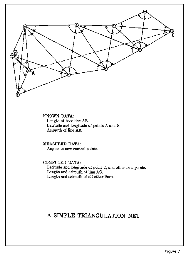
Basically, triangulation consists of the measurement of the angles of a series of triangles. The principle of triangulation is based on simple trigonometric procedures. If the distance along one side of a triangle and the angles at each end of the side are accurately measured, the other two sides and the remaining angle can be computed. Normally, all of the angles of every triangle are measured for the minimization of error and to furnish data for use in computing the precision of the measurements. Figures 7. Also, the latitude and longitude of one end of the measured side along with the length and direction (azimuth) of the side provide sufficient data to compute the latitude and longitude of the other end of the side.
The measured side of the base triangle is called a base line. Measurements are made as carefully and accurately as possible with specially calibrated tapes or wires of invar, an alloy highly resistant to changes in length resulting from changes in temperature. The tapes or wires are checked periodically against standard measures of length (at the Bureau of Standards in the United States and corresponding agencies in other countries). The geodimeter and tellurometer, operating on electro-optical and electronic principles respectively, have replaced the older methods of base measurement in the recent surveys. The work can be completed more rapidly and accurately than with wire or tape. The laser equipped geodimeter has proven to be the most accurate and it can measure much longer distances without losing accuracy.
To establish an arc of triangulation between two widely separated locations, a base line may be measured and longitude and latitude determined for the initial point at one end. The locations are then connected by a series of adjoining triangles forming quadrilaterals extending from each end. Figure 7. With the longitude, latitude, and azimuth of the initial points, similar data is computed for each vertex of the triangles thereby establishing triangulation stations or geodetic control stations. The coordinates of each of the stations are defined as geodetic coordinates. Figure 8.
FIGURE 7 A SIMPLE TRIANGULATION NET
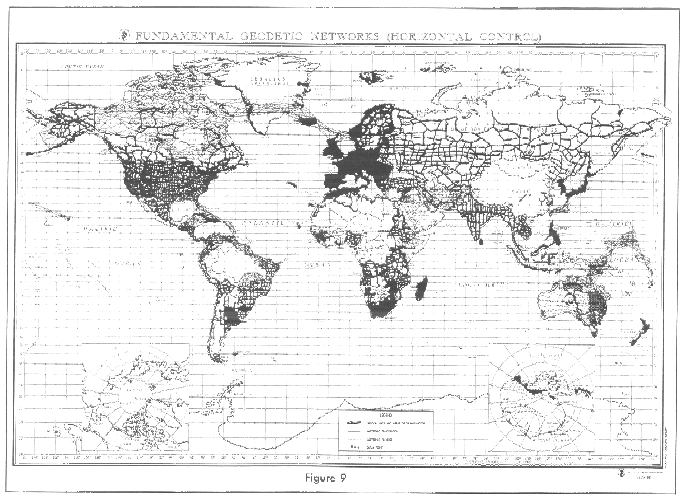
Triangulation is extended over large areas by connecting and extending series of arcs and forming a network or triangulation system. The network is adjusted in a manner which reduces the effect of observational errors to a minimum. A denser distribution of geodetic control is achieved in a system by subdividing or filling in with other surveys. Figure 9 serves to illustrate, in a general manner, the major triangulation networks which have been established.
FIGURE 9 FUNDAMENTAL GEODETIC NETWORKS (HORIZONTAL CONTROL)
There are four general orders of triangulation. First-Order (Primary Horizontal Control) is the most accurate triangulation. It is costly and time-consuming using the best instruments and rigorous computation methods. First-Order triangulation is usually used to provide the basic framework of horizontal control for a large area such as for a national network. It has also been used in preparation for metropolitan expansion and for scientific studies requiring exact geodetic data. Its accuracy should be at least one part in 100,000.
Second-Order, Class I (Secondary Horizontal Control) includes the area networks between the First-Order arcs and detailed surveys in very high value land areas. Surveys of this class strengthen the US National Horizontal Control Network and are adjusted as part of the network. Therefore, this class also includes the basic framework for further densification. The internal closures of Second-Order, Class I triangulation should indicate an accuracy of at least one part in 50,000. The demands for reliable horizontal control surveys in areas which are not in a high state of development or where no such development is anticipated in the near future justifies the need for a triangulation classified as Second-Order, Class II (Supplemental Horizontal Control). This class is used to establish control along the coastline, inland waterways and interstate highways. The control data contributes to the National Network and is published as part of the network. The minimum accuracy allowable in Class II of Second-Order is one part in 20,000.
Third-Order, Class I and Class II (Local Horizontal Control) is used to establish control for local improvements and developments, topographic and hydrographic surveys, or for such other projects for which they provide sufficient accuracy. This triangulation is carefully connected to the National Network. The work should be performed with sufficient accuracy to satisfy the standards of one part in 10,000 for Class I and one part in 5,000 for Class II. Spires, stacks, standpipes, flag poles and other identifiable objects located to this accuracy also have significant value for many surveying and engineering projects.
The sole accuracy requirement for Fourth-Order triangulation is that the positions be located without any appreciable errors on maps compiled on the basis of the control.
Normally, triangulation is carried out by parties of surveyors occupying preplanned locations (stations) along the arc and accomplishing all the measurements as they proceed. When distances between two points were too long for conventional methods, connections were sometimes made by a method known as flare triangulation. Stations were occupied on either side of the gap and magnesium flares were parachuted from aircraft or "shot" into the air from ships at suitable points between them. Intersections of lines were made simultaneously at all of the stations and reasonably accurate "bridges" established. A connection of this type was established between Norway and Denmark. However, satellite geodesy (Chapter VI) has solved the problem of bridging wide gaps.
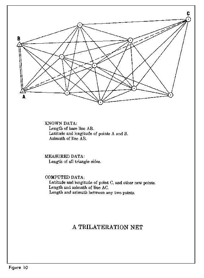
Trilateration
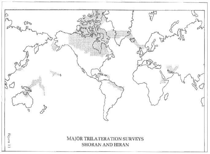
Another surveying method that has been used involves the use of radar and aircraft. The SHORAN, HIRAN and SHIRAN electronic distance measuring systems have been applied to performing geodetic surveys by a technique known as trilateration. Figure 10. Since very long lines (to 500 miles) could be measured by these systems, geodetic triangulation networks have been extended over vast areas in comparatively short periods of time. In addition, the surveys of islands and even continents separated by extensive water barriers have been connected by the techniques. The Canadian SHORAN network connecting the sparsely populated northern coastal and island areas with the central part of the country and the North Atlantic HIRAN Network tying North America to Europe are examples of the application of the trilateration technique. Figure 11 shows these and several other trilateration networks (SHORAN and HIRAN) which have been established throughout the world. SHIRAN has been used in the interior of Brazil.
FIGURE 11 MAJOR TRILATERATION SURVEYS SHORAN AND HIRAN
Only distances are measured in trilateration and each side is measured repeatedly to insure precision. The entire network is then adjusted to minimize the effects of the observations errors. The angles of the triangles are computed so the geodetic positions are obtained as in triangulation.
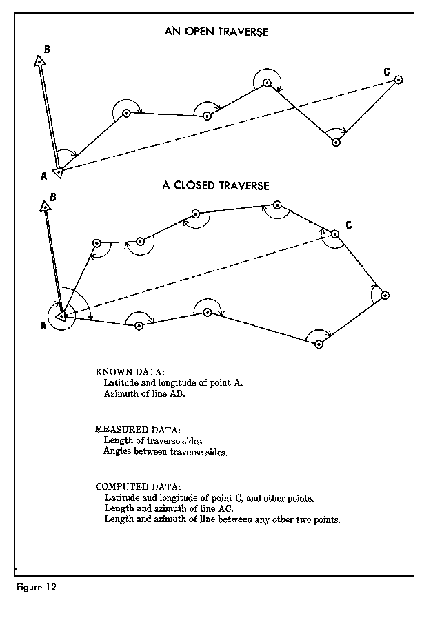
Traverse
The simplest method of extending control is called traverse. The system is similar to dead reckoning navigation where distances and directions are measured. In performing a traverse, the surveyor starts at a known position with a known azimuth (direction) to another point and measures angles and distances between a series of survey points. With the angular measurements, the direction of each line of the traverse can be computed; and with the measurements of the length of the lines, the position of each control point computed. If the traverse returns to the starting point or some other known position, it is a closed traverse, otherwise the traverse is said to be open. Figure 12.
FIGURE 12 AN OPEN TRAVERSE; A CLOSED TRAVERSE
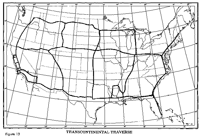
Since electronic distance measuring equipment has become available, the accuracy of traverse surveys has increased significantly. The tellurometer (microwave) has been used in Australia to complete a network (Australian Geodetic Datum) covering that continent. The average loop length is about 900 miles; the average loop closure of this work is 2.2 parts per million. The laser equipped geodimeter has been used to produce internal accuracies better than one part per million in establishing the transcontinental traverse in the United States. The traverse consists of a series of high-precision length, angle and astronomic azimuth determinations running approximately east-west and north-south through the conterminous states, forming somewhat rectangular loops. Figure 13. This traverse will be the "backbone" of a re-adjustment of the horizontal control network in this country.
FIGURE 13 TRANSCONTINENTAL TRAVERSE
Celestial Techniques
Celestial methods in geodesy involves the determination of an observer's position from observations of the moon, stars and satellites. Celestial triangulation permits the extension of long arcs across oceans and inaccessible space terrain. Satellites also permit a determination of the shape of the earth and provide important knowledge of its gravitational field (discussion of satellite geodesy is reserved for Chapter VI). All of the celestial methods possess one common characteristic-observed data is not affected by the direction of the vertical at the observation point.
Geodetic experiments have been performed in the past with the solar eclipse, star occultation and moon-position camera methods, but for various reasons the experiments did not produce useful geodetic results. The three techniques have been replaced by the observation and tracking of artificial earth satellites.
Vertical surveying is the process of determining heights-elevations above the mean sea level surface. As noted earlier, the geoid corresponds to the mean level of the open sea. In geodetic surveys executed primarily for mapping purposes, there is no problem in the fact that geodetic positions are referred to an ellipsoid and the elevations of the positions are referred to the geoid. However, geodetic data for missiles requires an adjustment in the elevation information to compensate for the undulations of the geoid above and below the regular mathematical surface of the ellipsoid. The adjustment uses complex advanced geodetic techniques. One method based on Stokes' Theorem is mentioned in the discussion of physical geodesy (Chapter V).
Precise geodetic leveling is used to establish a basic network of vertical control points. From these, the height of other positions in the survey can be determined by supplementary methods. The mean sea level surface used as a reference (vertical datum) is determined by obtaining an average of the hourly water heights for a period of several years at tidal gauges.
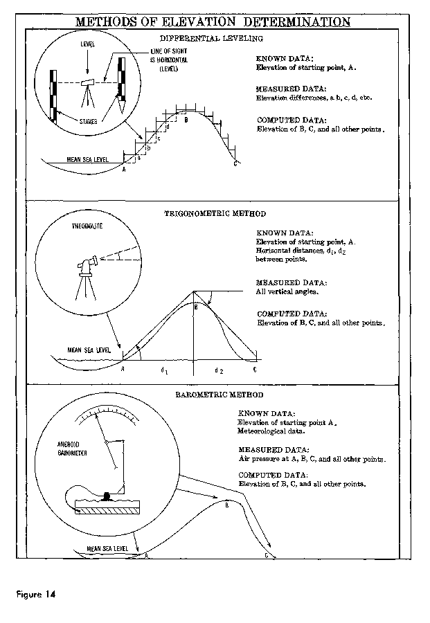
There are three leveling techniques-differential, trigonometric, and barometric-which yield information of varying accuracy. Figure 14. Differential leveling is the most accurate of the three methods. With the instrument locked in position, readings are made on two calibrated staffs held in an upright position ahead of and behind the instrument. The difference between readings is the difference in elevation between the points.
FIGURE 14 METHODS OF ELEVATION DETERMINATION
The optical instrument used for leveling contains a bubble tube to adjust it in a position parallel to the geoid. When properly "set up" at a point, the telescope is locked in a perfectly horizontal (level) position so that it will rotate through a 360 arc. The exact elevation of at least one point in a leveling line must be known and the rest computed from it.
Trigonometric leveling involves measuring a vertical angle from a known distance with a theodolite and computing the elevation of the point. With this method, vertical measurements can be made at the same time horizontal angles are measured for triangulation. It is, therefore, a somewhat more economical method but less accurate than differential leveling. It is often the only practical method of establishing accurate elevation control in mountainous areas.
In barometric leveling, differences in height are determined by measuring the difference in atmospheric pressure at various elevations. Air pressure is measured by mercurial or aneroid barometers, or a boiling point thermometer. Although the degree of accuracy possible with this method is not as great as either of the other two, it is a method which obtains relative heights very rapidly at points which are fairly far apart. It is widely used in the reconnaissance and exploratory surveys where more exacting measurements will be made later or are not required.