| PID:
|
BBFS77 |
| Designation:
|
CORYDON MAG STA |
| Stamping:
|
NO STAMPING |
| Stability:
|
May hold, commonly subject to ground movement |
| Setting:
|
Unspecified rock or boulder |
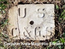
| Description:
|
6x8 inch US C&GS limestone post 3 ft long per C&GS pub Magnetic Declination Tables and Isogonic Charts 1902 p.313. Post cracked. Flush to surface.
Set to calibr. compasses by sights courthouse LE0526 and Baptist Church both now destroyed.
In west part Corydon IA Cemetery; 10.2 ft NW of NW corner W.H.Abel stone, tallest in area, 17.3 ft West of NW corner Milton Richardson, and 9.2 ft ESE of SE cor base Nellie Hubbard.
Point is bottom of 12 mm, 0.04 ft deep hole. |
| Observed:
|
2017-08-12T15:12:00Z |
| Source:
|
OPUS - page5 1603.24 |
|
|
|
| Close-up View
|
|