

Using the BUTTONWOOD as a Level Instrument
Orthometric heights (H) are referenced to an equipotential surface, e.g., the geoid. The orthometric height of a point on the Earth's surface is the distance from the reference surface to the point, measured along the plumb line normal to the geoid. Ellipsoid heights (h) are referenced to a reference ellipsoid. The ellipsoid height of a point is the distance from the reference ellipsoid to the point, measured along the line which is normal to the ellipsoid. At a given point, the difference between its ellipsoid height and orthometric height is defined (with sufficient accuracy) as its geoid height (N).
Orthometric height differences (dH) can then be obtained from ellipsoid height differences by subtracting the geoid height differences (dN):
| dH | = | dh - dN | (9) |
Conventional geodetic leveling and tidal observations determine heights relative to a surface which approximates the physical sea level surface (the geoid). GPS determines heights relative to a mathematical surface (the ellipsoid). The true sea level surface (which defines all charted depths) is only approximated by a sparse set of tide station observations averaged over long periods of time, hence limiting the accuracies of charted depths.
GPS, on the other hand, can provide consistent depths and heights for a dense network on the ellipsoid. In a different phase of NOS' San Francisco Bay Project, using GPS results and tidal information, the relationships between ellipsoid heights of tidal bench marks and local sea level measurements, e.g., mean low water and mean lower low water, were established at the Golden Gate, Alameda, and Richmond PORTS (Zilkoski and D'Onofrio, 1996). This provides ellipsoid heights for local water level values placing water levels on a common, accurate, spatially referenced datum rather than approximated sea level heights. An adequate knowledge of the difference between the geoid and ellipsoid surfaces is necessary for full implementation of the height modernization effort.
The ultimate goal is to map the bottom of the Bay in the ellipsoid height system and use GPS on ships in an electronic chart display to transit the Bay and dock during zero visibility. The electronic chart display would generate a warning message to the pilot if the ship gets too close to the bottom of the channel. This will happen, it is only a matter of time, but until tide levels and bottom depths are in the GPS system, GPS-ellipsoid heights need to be converted to heights relative to the geoid using equation 9 above, i.e., GPS-derived orthometric height = GPS-derived ellipsoid height minus geoid height.
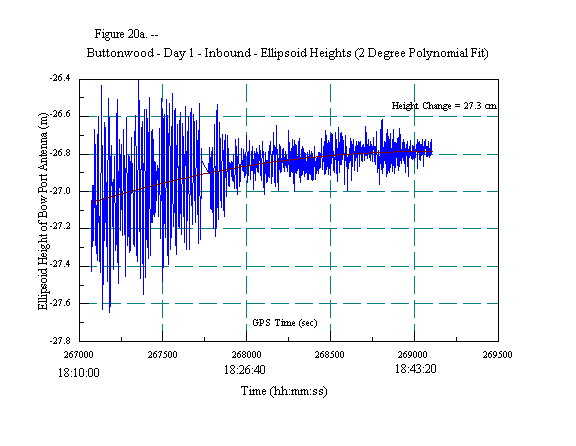
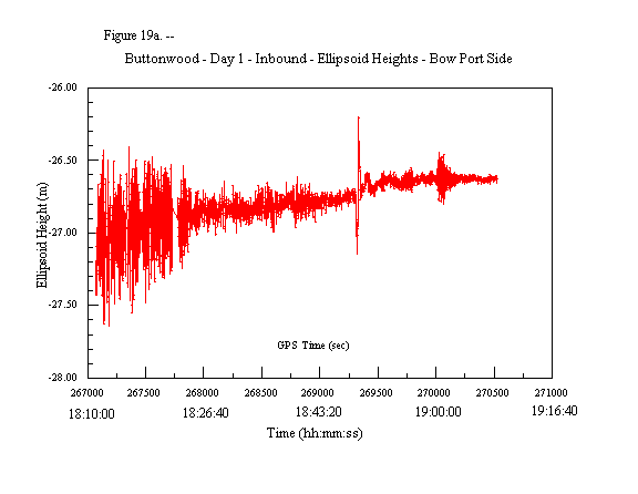
Figure 19a depicts the ellipsoid height of the bow port side GPS antenna, figure 19b depicts the geoid height for the same antenna based on its latitude and longitude value, and figure 19c depicts the GPS-derived orthometric height of the antenna using equation 9 above. Figures 19a and 19c indicate that there is a large change in height of the antenna at about GPS time 269,200 (18:46:40 local time). As previously mentioned, and shown in figure 16b, most of this change is due to a decrease in speed of the vessel. Therefore, to show the differences between the three height systems, height values were plotted for the period when the ship was at a fairly constant speed, i.e., GPS times 267,200 (18:13:20 local time) to 269,200 (18:46:40 local time). (See figure 16b.)
Figures 20a, 20b, and 20c depict the three heights, i.e., ellipsoid, geoid, and orthometric, respectively, for GPS times 267,200 (18:13:20 local time) to 269,200 (18:46:40 local time). A two-degree polynomial was fitted to the ellipsoid data to remove the movement of the ship due to wave action. A straight line was fitted to the plot of the orthometric height, which is what should be expected of a level water surface. Notice that the ellipsoid height change is about 27.3 cm, the geoid height difference is about 18.5 cm, and the orthometric height is only 8.8 cm. Looking at figure 20a, the ellipsoid height of the ship makes it appear that the ship is climbing a hill of water, but figure 20c, the orthometric height of the ship, clearly shows that the ship is traveling on a fairly level surface. This is because ellipsoid heights do not represent which way water flows, i.e., they are not related to the geoid, and orthometric heights in a small areal extent do represent which direction water will flow.
A portion of the 8.8 cm difference in orthometric height is due to errors in GPS height differences, as well as errors in geoid heights. Zilkoski and D'Onofrio (1996) showed a very small tilt between the published National geoid model and a GPS/leveling-derived geoid model for the San Francisco Bay. This tilt resulted in a height change of less than 8 cm from the west side of San Francisco to the east side of Oakland, but clearly indicates that a portion of the 8.8 cm is due to remaining errors in the geoid model. This indicates the importance of relating North American Vertical Datum of 1988 (NAVD 88) bench marks and tidal bench marks to the ellipsoid height reference system. All of these conversions can be made transparent to the user. It is, however, very important that these conversions are performed correctly.
Looking at figure 20c, there appears to be a change in the water level from when the ship is outside the Golden Gate Bridge, i.e., GPS times 267,200 (18:13:20 local time) to 267,750 (18:22:30 local time), to when the ship is inside the Bay, i.e., GPS times 267,750 (18:22:30 local time) to 269,200 (18:46:40 local time). The orthometric height data were separated into two data sets, before and after the Golden Gate Bridge. Figure 21a is a plot of the orthometric heights when the ship is outside the Golden Gate Bridge and figure 21b is a plot of the heights when the ship is inside the Bay. Notice that the slope of a fitted straight line to the data is about the same, i.e., it is 3.2 cm before the bridge and 3.7 cm after the bridge. Also notice that the mean height is 5.464 m before the bridge and it is 5 cm higher after the bridge, i.e., 5.516 m. This may be indicating that the water level outside the Bay is 5 cm lower than the water level inside the Bay. However, the GPS equipment lost lock on all satellites when it went under the bridge and had to reinitial and determine new integers for the satellites. Is this 5 cm shift due to processing of the GPS data or an actual difference in water level? Specially designed investigations will have to performed to determine the truth.
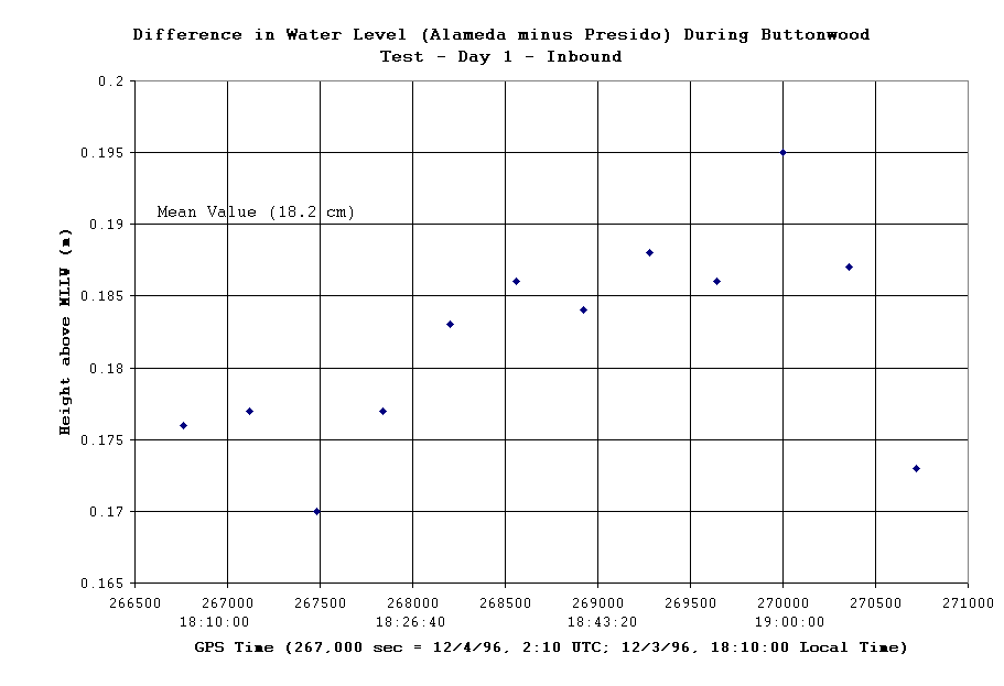
In addition, due to the tides, the actual water level has changed because the ship takes time to travel from outside the Golden Gate to inside the Bay. Figure 22 is a plot of the difference in observed water level obtained from the PORTS between Alameda and the Golden Gate Bridge during the same time interval that the ship was traveling at a constant speed, i.e, figure 20c. Notice that the water level difference between Alameda and the Golden Gate Bridge from GPS times 267,750 (18:22:30 local time) to 268,500 (18:35:00 local time) changed about 1 cm with Alameda being higher than the Golden Gate. GPS on the ship indicates about a 3.7 cm change in height in the same direction, i.e., the height value is higher closer to Alameda than the height value near the Golden Gate Bridge. This is clearly within the noise level of the GPS data, but it does indicate the great potential that GPS has to measure heights of ships above MLLW as well as the actual water level itself.