

Results of the USCG Buoy Tender GPS Test
For the test, GPS phase double-differences with carrier-phase ambiguities fixed to integers were used to compute 1-second epoch-by-epoch relative components ( X, Y, Z) of each antenna from the base station on Yerba Buena Island. These relative components were used to compute the X, Y, and Z values of the phase center of the antennas. The X, Y, and Z values of the phase center of the antennas were then used to compute the local vector components (e, n, u) and the vessel's roll, pitch, heading, speed, and squat (dynamic draft) as described in the previous section. As previously stated, the USCG ship test was a ship of opportunity. USCG in San Francisco was interested in partnering with NOS to obtain a better understanding of how GPS can be used to compute a vessel's attitude and the BUTTONWOOD was available during the first week of December. NGS had five Trimble SSE GPS instruments made available from the California Department of Transportation (Caltrans) for the test, but Trimble contacted NGS and asked if Trimble could participate in the test by providing the latest Trimble receivers with the latest firmware. The last piece of equipment was the heave, pitch, roll device, TSS-335B, installed by CS. The TSS-335B data were recorded on a laptop computer running on an accurate time base which was independent of the GPS data recorders.
The TSS-335B is a strap-down inertial sensor comprised of three linear and three angular accelerometers. The sensor provides heave, roll, and pitch outputs at 21 Hz. The roll and pitch have a low-pass response from DC to 3 Hz. The heave has a band-pass response from 0.05 to
3 Hz. For optimum accuracy the sensor position relative to the roll/pitch center of the ship needs to be known to within 5 cm in x, y, z. In the usual NOS application of the TSS-335B, a specific calibration procedure is performed to determine the station offsets in roll and pitch between the sensor and the ship. In this installation, the sensor was secured to a large built-in metal workbench in the engine room, close to the vessel's roll/pitch center. This temporary mounting technique compromised the absolute accuracy of the TSS-335B roll and pitch, but should not have compromised the relative accuracy of the role/pitch values. This was accommodated during processing of the data by forcing agreement between the long-term roll/pitch as determined by GPS and the TSS-335B. The station offsets between the two techniques were less than 2 degrees in roll and less than 3 degrees in pitch.
NGS' role in this phase was to collect and process the GPS data and use the GPS results to compute the vessel's pitch, roll, heading, apparent speed, and squat, as well as document the results. Using the four receivers on the ship, it was possible to compute two estimates of pitch and roll and compare the results to obtain an estimate of precision. NGS processed the data from each receiver on the ship relative to the base station on Yerba Buena Island. It is well known that this is not the most accurate method of estimating the vessel's attitude, but does provide a good estimate of accuracy of ellipsoid height differences, which is required to meet the overall goal of the project, i.e., to provide the position of the keel to within 10 centimeters relative to the bottom of the shipping channel. Processing the data between antennas on the ship should provide better accuracy of coordinate differences and therefore more accurate estimates of pitch, roll, and heading, but the ship's squat is limited by the accuracy of ellipsoid height estimates of an antenna relative to a base station.
All of the data have been processed and are being analyzed. For this report, the results using data obtained on day 1 traveling inbound, i.e., from the Golden Gate Bridge to Yerba Buena Island, are presented. Two estimates of pitch, two estimates of roll, and two estimates of heading were computed. The differences between these estimates provide an estimate of the precision of the system. Since all data collected were in Trimble's data format and the Trimble program is user-friendly, Trimble's GPSurvey software was used to process all data. A small subset of data was also processed using NGS' KARS software (processed by Gerry Mader, NGS' Geosciences Division, using a UNIX version) and the results were compared to GPSurvey's results. The comparison indicated that the two solutions typically agreed to better than 1 centimeter. The north and east components were much better than the up component.
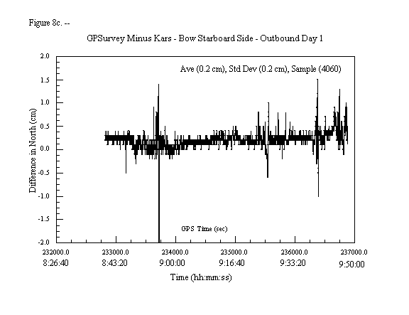
Figures 8c, 8d, and 8e depict the differences in north, east, and up component estimates between KARS and GPSurvey software for the Bow Starboard antenna during the outbound trip on day 1. Notice that the north and east differences are all typically less than 1 centimeter, and even though the up component exceeds 5 cm, there is no apparent large systematic bias between the two solutions and the average values are 0.2 cm for the north component difference, 0.5 cm for the east component difference, and 1.1 cm for the up component difference. It should be noted that no attempt was made to account for differences in how the software reject data, fix cycle slips, and how they handle atmospheric modeling, i.e., the comparison may not be comparing apples to apples. The authors only wanted to show that GPSurvey's software package provides reasonable results to demonstrate the concept for accurately positioning ships using GPS. The purpose of this phase of the project was to demonstrate the concept of using GPS to position large vessels, not evaluate GPS processing programs. Evaluation of software programs will be a part of the overall implementation of real-time positioning of ships using GPS which will be performed at a later date.
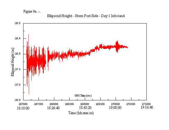
Figures 9a - 9d are plots that depict the antenna's ellipsoid height in meters, epoch-by-epoch, for each antenna on the ship. Notice that near the Golden Gate Bridge (GPS time 267,500, 18:18:20 local time) the ellipsoid height indicates that the ship is moving up and down about 70 cm (-27.3 m to -26.6 m) and when it is docked (GPS time 270,500, 19:08:20 local time) it is only moving a few centimeters. Another thing to notice is that at about GPS time 270,100 (19:01:40 local time), something happened to make the ship move up and down about 30 cm. This corresponds to a small increase in speed and a change in heading. This will be discussed in more detail later in the report.
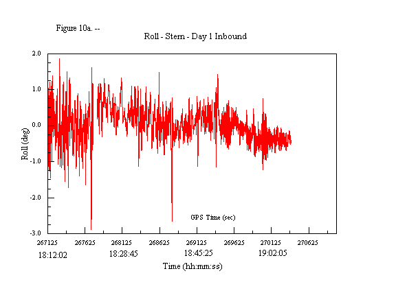
Figures 10a - 10d depict the vessel's roll values. Figures 10a and 10b depict the roll in degrees and 10c and 10d present it in meters. Once again, the values indicate that the vessel is rolling more at the Golden Gate Bridge than when it is approaching the pier. Figure 10e depicts the differences between roll values estimated using two sets of receivers. This is an indication of precision if it is assumed that the bow and stern are rolling the same. This should be a valid assumption for this ship under these conditions. It should be noted that this is not always true for larger ships. Most differences are indicating that the estimates of roll are being computed to within the 10-centimeter accuracy requirements. Notice that they are larger the farther away the vessel gets from the base station. The base station is within 200 meters of the ship when it is docked at the pier, i.e., GPS time 270,500 (19:08:20 local time). Also, notice that there appears to be a small tilt between the two solutions from GPS times 267,750 (18:22:30 local time) to 268,700 (18:38:20 local time). This tilt may be due to an incorrect estimate of an integer bias value or effects due to local site-specific multipathing. It occurs after the ships travels under the Golden Gate Bridge when all satellite signals were lost and seems to fix itself when a new satellite, SV 15, comes into view and was included in the solution at GPS time 268,700 (18:38:20 local time).
This deserves additional explanation. There were five satellites available when the receivers at the sip started collecting data at GPS time 267,200 (18:13:20 local time). The receivers lost lock on all satellites when the ship went under the Golden Gate Bridge at GPS time 267, 700 (18:21:40 local time) and reacquired lock after it cleared the bridge and entered the bay. The differences in roll estimates appear to be noisier prior to losing lock, but there doesn't appear to be any systematic tilt between their values before losing lock. There is an apparent systematic tilt after reacquiring lock and estimating new integer values. What is interesting is that this apparent tilt ends at about GPS time 268,700 (18:38:20 local time), which coincides with the introduction of another satellite, bringing the total number of satellites being tracked to six. There was no loss of data between GPS times 267,750 (18:22:30 local time) and 269,336 (18:48:56 local time). The solutions were processed in both forward and backward modes to determine if different solutions were obtained; the results were equivalent. All solutions obtained were fixed-integer solutions. If an incorrect integer were selected, the additional satellite may have provided enough redundancy to reduce its effect on the final solution.
To investigate this further, 30-second GPS data from the POINT BLUNT Continuously Operating Reference Station (CORS), which is located 7 kilometers northwest of station BUOY on Angel Island, were obtained from NGS' web site (http://www.ngs.noaa.gov) and used as the base station in place of station BUOY for computing the coordinates of the antennas on the ship. New roll and pitch values were then computed. The apparent tilt is still in the differences. Thirty-second data from base station BUOY were also used to recompute the coordinates and the results agreed with BUOY's 1-second data computations, i.e., the apparent tilt was still in the results. The differences between the 30-second and 1-second results were less than 3 mm.
Another interesting note is that the two base stations estimated different ellipsoid height values, which is expected, but the spread of the differences was +/- 4 cm. (See figure 10f.) Figure 10f is a plot of the differences in the estimates of the bow port antenna's ellipsoid height using the two base stations. There were some systematic differences that cancel when pitch and roll values are computed, but there are also some errors that remain. Figure 10g depicts the differences in the differences in ellipsoid heights between the bow starboard antenna and the bow port antenna estimated using both base stations. It is interesting to note that the differences are near zero between 267,000 (18:10:00 local time) and 268,000 (18:26:40 local time), then increase to +/- 4 cm between 268,000 (18:26:40 local time) and 268,600 (18:36:40 local time), decrease to zero between 268,600 (18:36:40 local time) and 269,000 (18:43:40 local time), and then increase to +/- 4 cm from 269,000 (18:43:40 local time) to the end. The changes do not correspond to loss of satellite signals. Station BUOY is, however, closer to the ship from time 269,000 (18:43:40 local time) to the end. The differences may be a result of how far the base station is from the roving receiver. When the two base stations are about the same distance from the receiver, they appear to give the same result and when they are closer to the base station, it provides a slightly different result. The differences may also be a result of different multipathing at the base stations and/or different tropospheric effects between the two stations. Station BUOY used a 2-meter fixed height pole and station POINT BLUNT is on a 6-meter tower.
To evaluate possible differences between the two base stations, a kinematic solution between POINT BLUNT and BUOY was performed. POINT BLUNT was selected as the base and BUOY was named the rover. Since BUOY is not actually moving, the 30-second epoch-by-epoch estimates of BUOY's coordinates should not change. The different values will be partly due to site-specific effects that do not cancel, i.e., effects due to different multipathing and unmodeled tropospheric effects. Figure 10h is a plot that depicts the difference in ellipsoid height estimates epoch-by-epoch between POINT BLUNT and BUOY during the same time as Figure 10f. There is an apparent correlation between the two plots. Figure 10i is a plot of the differences between figures 10f and 10h. Notice that from GPS times 267,000 (18:10:00 local time) to 268,000 (18:26:40 local time) the tilt in the differences is the same, i.e., the differences between figures 10f and 10h are near zero with a 5 mm bias, implying whatever was influencing the solution between POINT BLUNT and BUOY was also influencing the difference in solution between POINT BLUNT and the bow starboard antenna and BUOY and the bow starboard antenna, i.e., difference in multipath at the two base stations. The differences between 268,000 (18:26:40 local time) and 270,500 (19:08:20 local time) appear to be noisier than the first 1,000 seconds (16 minutes, 40 seconds), but still appear to less than differences between POINT BLUNT and BUOY as depicted in figure 10h. Once again possibly indicating that local effects at the base stations are causing small differences in estimating ellipsoid heights. These small differences, i.e., +/- 5 cm, are significant when the system desired is to be within 10 cm. These data are still being investigated, but this shows the importance of having redundant systems on board the ship as well as on land.
Figures 11a - 11e depict the vessel's pitch values. Figures 11a and 11b depict the pitch in degrees and 11c and 11d present it in meters. As in the previous plots, these plots indicate that the ship is pitching more outside the Golden Gate Bridge than when it is inside the Bay. Notice that there is an increase and then an immediate decrease in pitch around time 270,100 (19:01:40 local time). This corresponds to the time the ship started its docking maneuvers. There are corresponding changes in heading, shown on figure 12, and speed, shown on figure 13 at time 270,100 (19:01:40 local time). Figure 11e shows the differences between pitch computed using the starboard side GPS equipment and pitch estimated using the port side set of GPS equipment. It should be noted that there is a tilt between the two pitch solutions similar to the tilt seen in the two estimates of the roll of the ship. These differences are still all within the 10 cm requirement and are much better than 10 cm when the ship is closer to the base station.
Figure 12 depicts the heading computed using the GPS equipment on the port side and figure 14a is the plot of the heading using the GPS equipment on the starboard side of the ship. Figure 14b is the difference between the two estimates of heading. Figure 14b indicates that the heading estimates are good to about 0.03 degrees. For the length of the ship (46.5 m), this translates into an error of about 2.5 cm. There also appears to be a bias of about 0.05 degrees between the two values. This translates into a linear error of about 4 cm, which is the difference between the base line distance of the bow antennas and the stern antennas.
Figures 15a - 15c are plots of the apparent ship speed based on the GPS results. Figures 15d - 15f are plots depicting the differences between estimates of the ship speed based on different sets of receivers. The results indicate that the ship speed was computed at about the 5 cm/sec level.
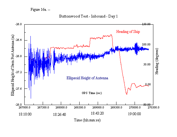
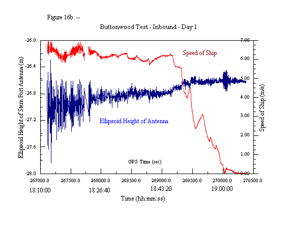
The ellipsoid height value of the GPS antenna on the ship varies due to many parameters, such as changes in heading or speed, as well as wave action. Figure 16a is a plot of the ellipsoid height of the antenna on the stern port side of the ship versus time with an overlay of the heading of the ship versus time. Figure 16b is a plot of the ellipsoid height of the antenna on the stern port side of the ship versus time with an overlay of the speed of the ship. An obvious correlation exists between the heading, speed, and ellipsoid height at time 270,000 (19:00:00 local time). This corresponds to when the ship was performing its docking maneuvers. What is more interesting is on figure 16b at time 269,200 (18:46:40 local time), when the speed of the ship starts to rapidly decrease. At the time the ship's speed decreases, the height of the antenna increases. This difference is what is known as the squat of the ship.
"Squat" (also known as dynamic draft) can be very important to large vessels because as they increase their speed, their keel gets closer to the bottom of the channel. If the bottom of the channel is known in the same system as GPS, then the relationship between the bottom of the ship and the bottom of the channel can be known to better than 10 cm (4 inches) in real-time.
Most large container vessels and tankers have flat bottoms, so as the ship rolls and pitches, parts of the bottom of the ship get closer to the bottom of the channel. When a large container ship (width about 135 feet) turns, its bottom gets possibly 30 cm (1 foot) closer to the bottom of the channel. The results shown in this test clearly indicate that the bottom of the ship can be determined to the 10 cm (4 inch) level. Some issues still need to be resolved for real-time operations such as ensuring the correct integer bias values have been selected using the OTF technique, but these related issues can be resolved by future studies.