 Variations in Sea Level
Variations in Sea Level
Variations in Sea LevelThe following topics will be discussed:
Sea Level Station Trend 1970-90 Trend 1930-90
_________________________________________________________
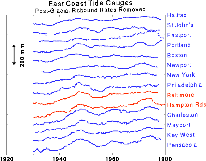
PORTSMOUTH 4.3 mm/year 3.8 mm/year
HAMPTON ROADS 1.1 4.2
GLOUCESTER POINT -1.5 (*)
CAMBRIDGE -3.2 3.2
WASHINGTON DC -1.8 3.0
SOLOMONS ISLAND 2.0 3.3
ANNAPOLIS -0.3 3.5
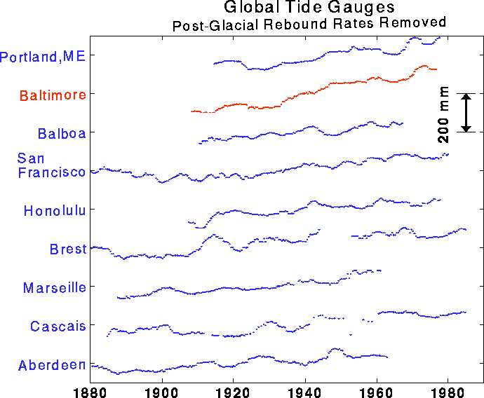
BALTIMORE -0.4 3.2
KIPTOPEKE BEACH 0.5 (*)
LEWES -0.5 3.3
PHILADELPHIA -0.5 2.7
_________________________________________________________
AVERAGE 0.0 mm/yr 3.4 mm/yr
(*) Data not available for the entire period 1930-60
The interval 1930-1990 is long enough at 60 years to establish
that the middle Atlantic region has a systematically higher rate
of sea level rise than the long term global average of nearly 2
mm per year. The approximately 1.5 mm/yr extra rise for the
region comes from a general sinking of the area into the ocean.
Postglacial rebound, that is, readjustment (sinking in this area)
of land elevations since the retreat of the glaciers at the end
of the last ice age, is the cause. The overall global rise of
sea level adds to the effect of land subsidence in the Chesapeake
area to produce an unusually high rate of long-term local sea
level rise relative to the global average.
The period 1970-1990 tells a very different story. The sinking of the land from postglacial rebound is still going on, but the regional ocean circulation and density structure has produced a temporary fall of sea level in the zone that has entirely offset the effect of the subsidence due to postglacial rebound. Thus for now, the net change of sea level in the middle Atlantic area is zero. Of course this situation will not last. The nearby ocean will inevitably recover, and even overshoot, its long term rate of sea level rise in the area, producing at some time in the future (probably in the next few decades) a rate of rise that exceeds the long term average rate for the region.
Examining the Table more closely, we see that several sites (Portsmouth, Solomons Island) still do show substantial positive values of sea level rise for the last 20 years. It is possible that these sites are subject to land subsidence beyond the regional value caused by postglacial rebound. A typical cause of such localized subsidence is groundwater extraction, which in fact has occurred in both areas at an ever increasing rate in recent decades. If this is indeed the case, when the ocean returns to something like its average behavior, very high and damaging rates of relative sea level rise (5 to 7+ mm/yr) will be observed at these locations for possibly many decades. Because of the observed rate, Solomon's Island was chosen as the first permanent GPS site for this project.
An excessive rate of sea level rise of a few mm/yr might at first glance appear to be of little consequence. But the slope of the coastal plain in the region is very shallow, being in many places less than 1 part in 1000. Thus a five mm rise of sea level in one year translates into a five or more meter loss of land! And this rate of loss can persist for decades.
Tide gauges measure sea level changes relative to the land on which the
the tide gauge rests. By itself, a tide gauge cannot tell the difference
between local crustal motion and sea level changes. The following figures
illustrate this point. The dashed red line is at a constant height in
all figures. In the first figure, the water level is fixed but
the land has fallen.
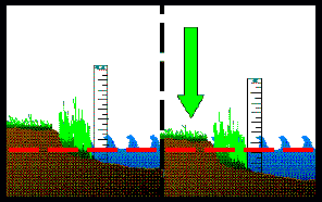 Crustal Motion
 Rising Sea Level
Land subsidence that results in a large rise of relative sea level and concomitant flooding of coastal areas has long plagued many communities. Houston, Galveston, and parts of Louisiana have had to undertake major programs to deal with these problems. It is urgent to monitor the land elevation at sites in the Chesapeake region by geodetic means as early as possible to see if similar problems are destined to occur in this area. In this way it will be possible to determine if groundwater extraction associated with commercial development and agricultural practices is having a deleterious effect on relative sea level rise and will hasten the loss of precious coastal lands and islands.
A more probable and catastrophic mechanism of marsh loss from increasing
sea levels is the formation of interior marsh ponds. If these ponds form,
the provide additional boundaries where sediment can be washed away destroying
the base from which the plants grow. These shallow-water bodies enlarge and
coalesce in response to sea level rise resulting in rapid coastal submergence
at the expense of marsh vegetation [Orson et al., 1985].
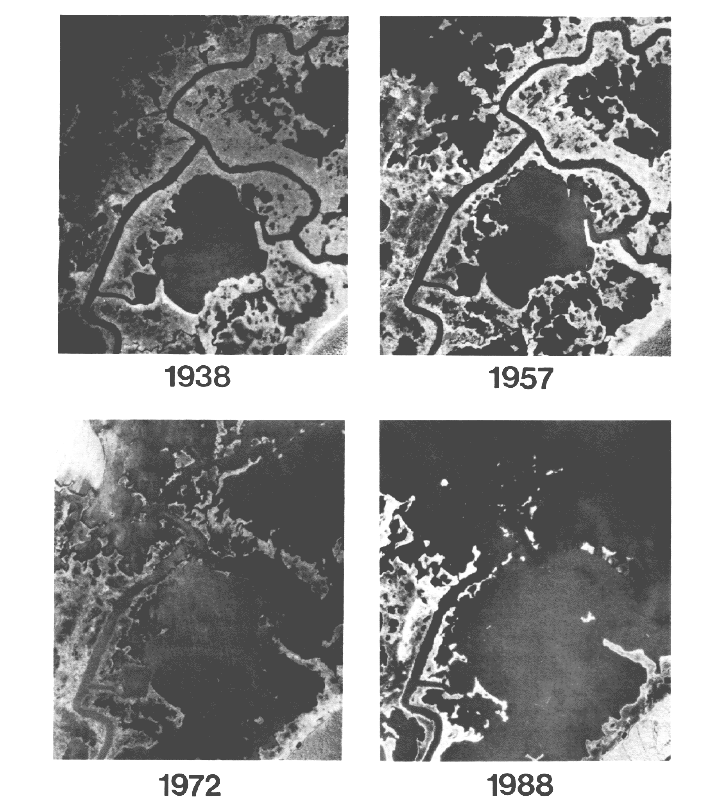
A striking example is shown in the images above taken at the Blackwater
National Wildlife Refuge in Maryland. The darker areas are the open water;
the lighter are vegetation. Note both the growth in number and size of the
interior marsh ponds.
Indirectly, sea level rise will exert other pressures on coastal marshlands. In response to a rising sea level, bulkheads will be built to control shoreline erosion. As the marshes attempt to migrate inland in response to sea level rise, they will literally be squeezed out of existence. New patterns of building and agriculture; conserving and clearing; planting and dredging will influence the evolution of the Chesapeake Bay marshlands.