Chesapeake Bay Project Info and Data
click on a symbol or name to get more information about that site.
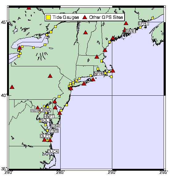
GPS Sites Used in this Project
Annapolis, MD - usna
Bar Harbor, ME - barh
Cape Henlopen, DE - chl1
Cape Henry, VA - chr1
Eastport, ME - eprt
Gloucester Point, VA - glpt
Greenbelt, MD - gode
Horn Point, MD - hnpt
Newport, RI - npri
Solomons Island, MD - sol1
Sterling, VA - strl
Wachapreague Island, VA - vims
Wallops Island, VA - wlps
Other Sites Processed as Part of this Project
Bermuda - brmu
Duck, NC - duck
Fort Macon, NC - fmc2
Sandy Hook, NJ - shk1
Tide Gauges Around the Chesapeake Bay
Annapolis, MD
Baltimore, MD
Cambridge, MD
Chesapeake Bay Bridge-Tunnel, VA
Colonial Beach, VA
Kiptopeake, VA
Lewes, DE
Lewisetta, VA
Gloucester Point, VA
Havre de Grace, MD
Solomons Island, MD
Wachapreague Island, VA
Washington, DC
Windmill Point, VA
The GPS data
are downloaded daily to the Geosciences Lab Data Center by
computer network and modem. The raw receiver data are converted to RINEX
formats, quality checked and made available by 8:00AM the next morning.
Questions can be directed to:
Miranda Chin (301)713-2852
The
NOAA precise GPS ephemerides are generated from a subset of the IGS
global GPS tracking network. Typically, a precise ephemeris is available
3-5 days after the fact.
To retrieve the data or ephemerides via anonymous FTP:
 address:  gracie.grdl.noaa.gov
    name:  anonymous
password:  your address
Individual daily data files are accessible from a subdirectory which can
be reached with the command:
cd dist/cignet
Under this directory, subdirectories named for and containing data for each
day can be found. The naming convention used is:
dddda_yy or ddddb_yy
where ddd is the day-of-year and yy is the
last two digits of the year. The fifth character is either an
a or b designating the storage location for
the ASCII (RINEX) or binary (RAW) files. The data files are compressed and
should be downloaded in binary mode.
Individual daily ephemerides are accessible from a subdirectory which can
be reached with the command:
cd dist/cignet/Ngsorbits
The files are named using the convention:
ngswwwwd.eph
where wwww is the four digit GPS week number and
d is the day of the week (Sunday = 0). The data files
are compressed and should be downloaded in binary mode.
Return to the Chesapeake Bay Project homepage