What is the geoid?
The geoid is a model of global mean sea level that is used to measure precise surface elevations.
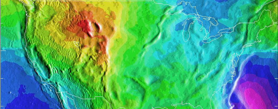
A depiction of the United States geoid. Areas in yellow and orange have a slightly stronger gravity field as a result of the Rocky Mountains.
Print your own geoid.
Do you have access to a 3D printer? Print your own scale model of the geoid with a free plan created by a NOAA geodesist! This model exaggerates the bumpy surface of the geoid so it is easy to see the irregular shape of the planet's global mean sea level and reduces the diameter of the Earth to just a few inches.
Please note that this model includes a wide, flat base that makes it easier to print on most home 3D printers. The base also serves as a stand to display the geoid model.
While we often think of the earth as a sphere, our planet is actually very bumpy and irregular.
The radius at the equator is larger than at the poles due to the long-term effects of the earth's rotation. And, at a smaller scale, there is topography—mountains have more mass than a valley and thus the pull of gravity is regionally stronger near mountains.
All of these large and small variations to the size, shape, and mass distribution of the earth cause slight variations in the acceleration of gravity (or the "strength" of gravity's pull). These variations determine the shape of the planet's liquid environment.
If one were to remove the tides and currents from the ocean, it would settle onto a smoothly undulating shape (rising where gravity is high, sinking where gravity is low). This irregular shape is called "the geoid," a surface which defines zero elevation. Using complex math and gravity readings on land, surveyors extend this imaginary line through the continents. This model is used to measure surface elevations with a high degree of accuracy.

