Geoid Slope Validation Surveys (GSVS)
The purpose of the Geoid Slope Validation Surveys (GSVS) is to determine the accuracy of gravity-based geoid models and to quantify the contribution of aerial gravity data acquired as part of the Gravity for the Redefinition of the American Vertical Datum (GRAV-D) project.
NGS has completed three GSVS surveys:
- Texas 2011 - Evaluation of geoid accuracy in a flat and gravimetrically uncomplicated region.
- Iowa 2014 - Evaluation of geoid accuracy in a flat, high elevation, and gravimetrically complex region.
- Colorado 2017 - Evaluation of geoid accuracy in a rugged, high elevation, gravimetrically and topographically complex region. This survey will provide a worst-case scenario to evaluate geoid modeling due to its complexity.
Types of Surveys
The GSVSs are composed of several different surveying methodologies, including:
- Long session GPS
- Spirit leveling
- Terrestrial gravity and vertical gravity gradient surveys
- Deflection of the Vertical (DOV)
The objective of performing these surveys is to compare the geoid slope from co-located (temporally and spatially) GPS, leveling and gravity, and DoV observations to the geoid slope of a gravimetric geoid created with and without airborne gravity data. By performing independent measurements, NGS is validating the models through actual observation, not modeling and forecasting.
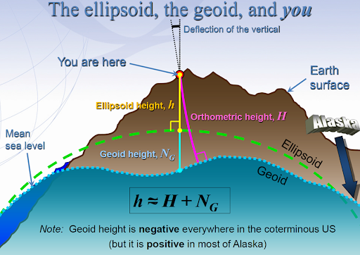
The ultimate goal for the new reference frames and geopotential datum is to model the Earth as best as we can so users of the National Spatial Reference System (NSRS) can get an accurate position and height using GPS. While GPS heights alone will not tell a user where water will flow, applying an accurate geoid model to the GPS observations will. NGS will essentially provide the "correction" to get orthometric heights from GPS determined ellipsoidal heights.