4.4. Data Processing Defaults
Data processing preferences govern aspects of both session processing and network adjustments. The defaults, as shown in Fig. 4.6, will generally ensure good results and are consistent with NGS recommended best practices.
Caution
Although the defaults can be changed at any time, changes made after processing may not be reflected in the already completed processing results requiring one to reprocess some or all of the session solutions and network adjustments.
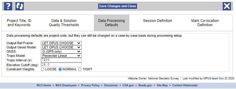
Fig. 4.6 Data Processing Defaults
Output Reference Frame:
Coordinates in the current ITRF/IGS are always included in the Processing Reports, but the coordinates in an additional reference frame (user selected) will be reported if possible. The default is “LET OPUS CHOOSE.” OPUS will choose the current realization of NAD 83 (required for submission to NGS), but other options are available.
Output Geoid Model:
A pull-down menu is used for the Output Geoid Model, so GNSS-derived ellipsoid heights can be converted to orthometric heights. The default, ‘LET OPUS CHOOSE,” uses the latest NGS hybrid geoid model applicable to the project location (required for submission to NGS) though other models are available, including some gravimetric geoids.
Caution
The conversion from ellipsoid heights to orthometric heights is done as a purely algebraic removal of the geoid undulation from the ellipsoid height. Those users familiar with “Height Modernization” should not confuse this conversion with an actual least squares adjustment performed in the orthometric height domain.
GNSS:
Currently the only choice in the “GNSS” pull-down menu is “G” (GPS-only), but the capability to use other GNSS in the data processing may be added in the future. Note that you may upload data files (RINEX) containing GLONASS data and the NGS may archive it, but the GLONASS data is currently stripped out automatically when processed by OPUS.
Tropo Model and Tropo Interval:
OP provides limited user control over how the effects of water vapor on the satellite signals as they traverse the tropospheric portion of the atmosphere, commonly called the tropo corrections, are parameterized (or modeled) in order to remove them. For submission of your project to NGS, it is recommended to keep the tropo model at piecewise linear approximation, with a tropo interval of 7200 seconds (2 hours). For additional information, see “Tropospheric Modeling” in the Glossary.
Elevation Cutoff:
The default Elevation Cutoff mask, in degrees above the horizon, can be specified. Data from satellites below the specified mask will be ignored. The default for new projects is 15 degrees. You will be given the opportunity to adjust the Elevation Cutoff mask separately for each session you process. This is a good idea for sessions containing user marks with impaired sky visibility.
Constraint Weights:
Constraint weights are only applied to user marks or CORSs selected to be held as constrained points in the project processing. Weights can be individually set in the sessions, and they can also be set here as defaults for all session processing and network adjustments. There is no differentiation between the weights applied to horizontal and vertical constraints. Users can select the constraint weights of choice for session processing and network adjustments with one exception: if a Project Tracking ID is used, constraint weights cannot be changed in the network adjustments; they are set to “NORMAL” for all network adjustments.
LOOSE -allows up to one meter of float for the constrained points in the processing.
NORMAL -allows up to one centimeter of float for the constrained points in the processing (this is the recommended choice).
TIGHT -allows up to one-tenth of a millimeter of float for the constrained points in the processing (effectively fixing and not allowing the constrained control points to move).