National Spatial Reference System (NSRS) Modernization Case Studies
The 2019 Geospatial Summit agenda included the expected impacts of the planned replacement of the North American Datum of 1983 (NAD 83) and the North American Vertical Datum of 1988 (NAVD 88).
We are exploring new ways to present this type of information, and we would like your feedback. Suggestions are welcome anytime if you would like to contribute to future Geospatial Summits or similar events.
Case Study Examples
Some agencies have tested whether the NSRS Modernization effort will impact their current products or workflows. For example:
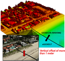
- NGS tested the impact of "mixing" reference frames and geopotential datums on lidar datasets and Digital Elevation Models (DEMs).
- NOAA's Office of Coast Survey tested whether the reference frame "coordinate shifts" would be noticeable on nautical charts.
- NGS partnered with FEMA to examine the impacts to the Floodplain Mapping Program. Read the final report online.
Sharing similar tests, studies or even study approaches will help:
- End-users complete their own testing and plan for the expected impact to their products.
- NGS develop their outreach and training resources.

