Friday, June 04, 2010
NOAA Developing Unified North American Geoid with International Partners (NGS)
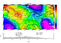 From May 31 to June 4, scientists from the National Geodetic Survey (NGS) met with international colleagues from Canada and Mexico at the Joint Canadian Meteorological and Oceanographic Society to continue the coordinated shift to a vertical reference system based on a scientific model of Earth's gravity field (geoid). NGS hosted a workshop to discuss long-term monitoring of geoid change, strategies to sample changes over time, and a process for appropriate geoid update. A consistent and updated North American geoid will provide an efficient means to calculate accurate heights in support of mapping, emergency planning, land use, and water management across North America. For more information, contact Vicki Childers.


