Transitioning from IGS14 to IGb14
What is this transition?
On May 17, 2020, the International GNSS Service (IGS) replaced the IGS14 reference frame with the newer IGb14 GNSS geodetic reference frame.
Why is there a need to update the IGS reference frame?
Since the end of the ITRF2014/IGS14 data input date (February 2015), a large number of IGS stations have experienced either real or apparent shifts in position due to earthquakes and antenna changes, respectively. These shifts, whether real or apparent, rendered the affected stations unusable for operational reference frame alignments, and the remaining usable reference frame stations now need to be extrapolated by more than 5 years, which can cause substantial errors. To address these issues, the IGS replaced the IGS14 reference frame with IGb14 on May 17, 2020. The new IGb14 has the advantage of 5 additional years of data than its predecessor frame IGS14.
How did this impact the NOAA CORS Network (NCN)?
While NCN stations are not immune to the issues described above, most don't contribute to the international frame, and so weren't included in the IGS analysis or coordinate update. As such, the majority of the CORS network retain their original ITRF2014 coordinates and velocities, until the entire frame is replaced, probably after the year 2020.
However, for the 49 globally dispersed IGS stations used in NGS's data processing, NGS did adopt the IGb14 frame, and has updated the published coordinates and velocities, including the NAD 83(2011/MA11/PA11) epoch 2010.00 coordinates published on the NGS datasheets. The previous NAD 83 coordinates derived from the IGS14 solution are listed as superseded.
Stations received coordinate updates as of May 2020?
ABMF,ALBH,ALGO,AMC2,AOML,BARH,BJCO,BREW,BRFT,BRMU,CHUR,CNMR,CRO1,DRAO,DUBO,FAIR,FLIN,FORT,GODE,GOL2,GOLD,GUAM,GUAT,GUUG,HNLC,HOLB,ISBA,KOKB,KWJ1,LMMF,MAUI,MDO1,MKEA,MONP,NLIB,NRC1,PIE1,PRDS,QUIN,SCH2,SCUB,STJO,USNO,VNDP,WES2,WHIT,WILL,WUHN,YELL
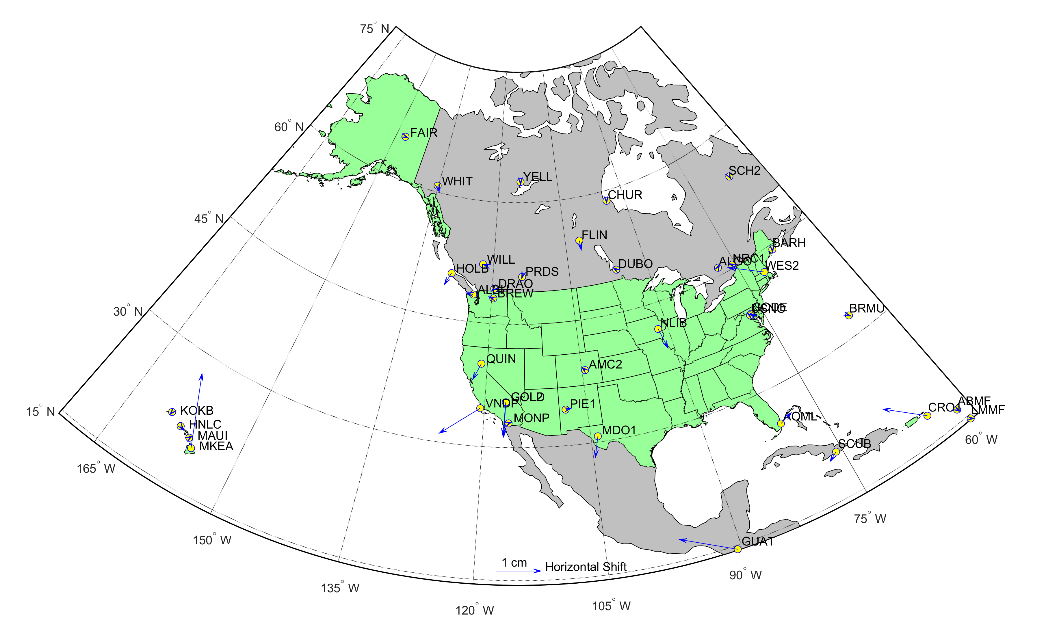
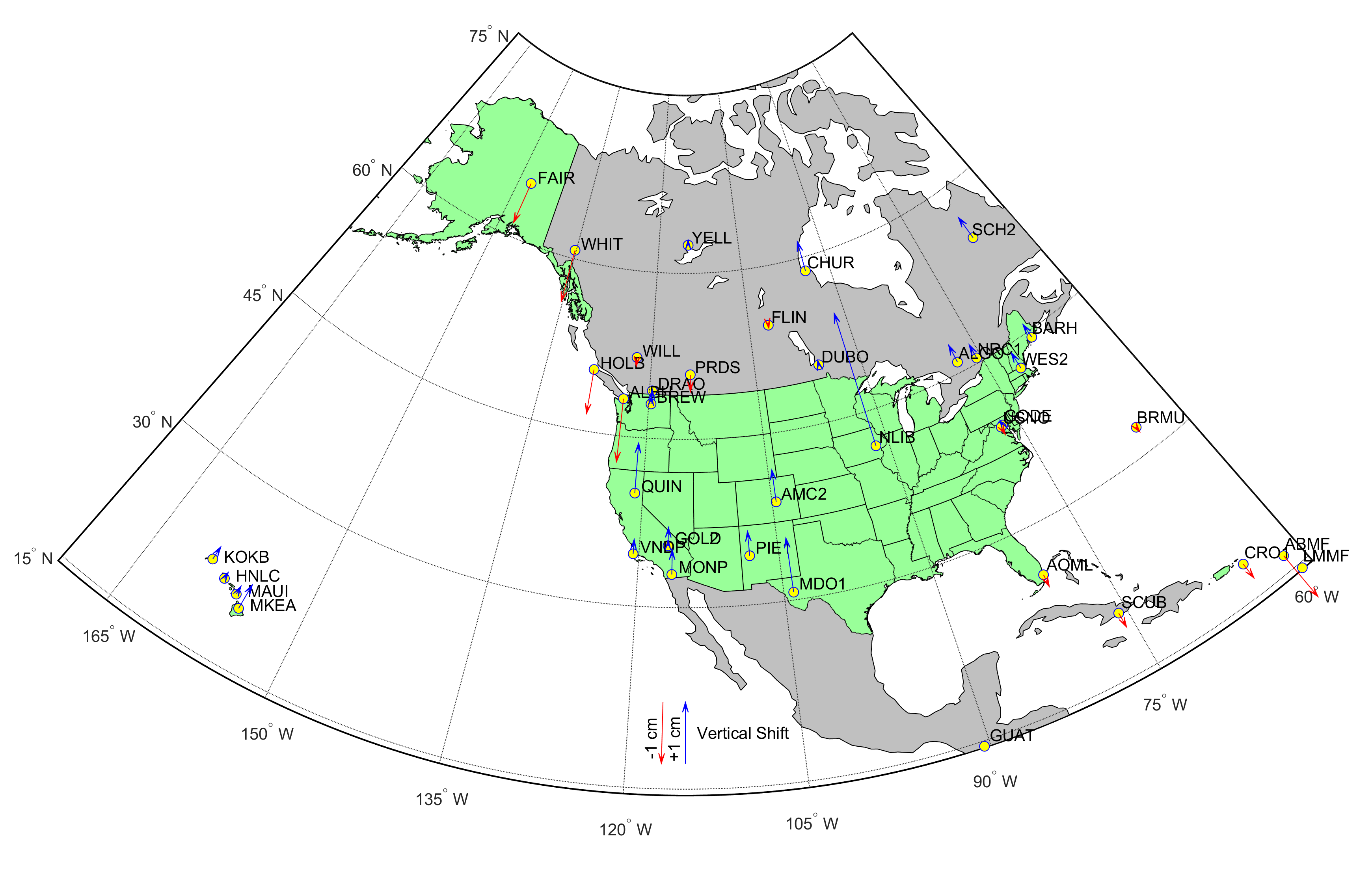
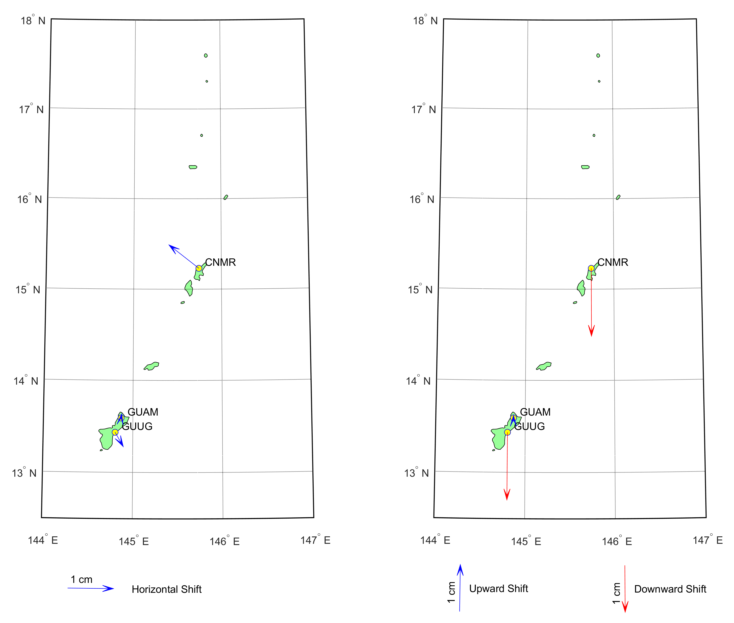
The figure below shows coordinate differences in east, north, and up between IGS14 and IGb14 for 48 of the 49 affected stations (the differences in their NAD 83 coordinates is the same). The differences were taken by propagating position and velocity information for each station to the transition date, May 17, 2020, in the respective frames and computing the difference at that epoch.
Note: The 49th affected station, ISBA, was not included in IGS14, and so does not appear in the figure.
Coordinate differences on May 17th, 2020

Horizontal shifts on May 17th, 2020
Vertical shifts on May 17th, 2020
Horizontal and vertical shifts in Guam on May 17th, 2020
What other NGS products and services were affected?
- OPUS: when referencing any affected stations, all OPUS products will use the newly published coordinates.
- Orbits: NGS began computing all of its orbit products in IGb14 to maintain consistency with the other analysis centers that contribute to the IGS.
- ADJUST was updated to work with IGb14. If you use ADJUST, please download the newest version after May 17th, 2020.
- HTDP was updated to work with IGb14. If you use HTDP, please download the newest version after May 17th, 2020.
- NGS baseline processing tools in OPUS and PAGE-NT was updated to work with IGb14 orbits.
