12.5. Network Adjustment Results
Once the processing is completed, output files will be available in a manner similar to session processing (email attachments and output files in OP under “Show File”).
The body of the email sent to the project manager will have an abbreviated summary of the solution. Note that this summary lists coordinate shifts (shown in the yellow highlight in the sample output below; the shifts will be discussed in more detail in Section 12.7).
Sample Network Adjustment Email
 NGS DEV OPUS-Projects 5.1 NETWORK ADJUSTMENT REPORT
 FOR network-final
 FROM PROJECT ODU GEODETIC CONTROL.
 SELECTED REPORTS ARE ATTACHED TO THIS EMAIL. ALL REPORTS ARE
 AVAILABLE THROUGH THE PROJECT'S WEB PAGE FOR THIS SOLUTION.


                   ABBREVIATED SUMMARY
 SUBMITTED BY:                  nick.forfinski-sarkozi
 SOLUTION FILE NAME:            network-final.sum
 SOLUTION SOFTWARE:             GPSCOM(2008.25)
 SOLUTION DATE:                 2022-06-08T15:06:26 UTC
 STANDARD ERROR OF UNIT WEIGHT: 0.798
 TOTAL NUMBER OF OBSERVATIONS:  107072
 TOTAL NUMBER OF MARKS:         12
 CONSTRAINED MARKS:             1 HORIZONTAL, 0 VERTICAL
 ou03 N36:53:11.86975 W076:18:13.50342  -34.294m        NAD_83(2011) @ 2010.0000
 ou03         0.09cm           0.08cm     0.16cm        NEU SIGMAS

 START TIME:                    2021-02-10T00:00:00 GPS
 STOP TIME:                     2021-02-10T23:59:30 GPS
 FREQUENCY:                     L1-ONLY TO ION-FREE [BY BASELINE LENGTH]
 OBSERVATION INTERVAL:          30 s
 ELEVATION CUTOFF:              15 deg
 TROPO INTERVAL:                7200 s [PIECEWISE LINEAR PARAMETERIZATION]
 DD CORRELATIONS:               ON

     INCLUDED SOLUTION            RMS    SOFTWARE         RUN DATE
 ------------------------------------------------------------------------------
  1) 2021-041 A                  1.6 cm  page5(2008.25)   2022-06-08T12:45 UTC
  2) 2021-041 B                  1.5 cm  page5(2008.25)   2022-06-08T13:01 UTC

   BASELINE      LENGTH         RMS       OBS   OMITTED    FIXED IN SOLUTION(S)
 ------------------------------------------------------------------------------
  wlp2-ls03     26.800 km      1.8 cm     4174     6.1%   100.0%    2
  brmr-ls03     31.256 km      1.5 cm     5185     4.2%   100.0%    1
  gp99-ls03     31.852 km      1.9 cm     4850     9.8%    97.9%    1
  ou03-ls03     32.569 km      1.6 cm     4849    11.0%   100.0%    1
  w416-ls03     32.688 km      2.1 cm     4571    14.6%    94.0%    1
  ou18-ls03     33.651 km      2.5 cm     4295    28.1%    94.3%    1
  863f-ls03     37.088 km      1.7 cm     4670    16.8%    94.4%    1
  ncel-ls03     56.385 km      1.4 cm    18639     2.5%    99.4%    1, 2
  vagp-ls03     70.089 km      1.5 cm    18787     1.3%   100.0%    1, 2
  nccr-ls03    107.294 km      1.4 cm    18723     1.8%    75.4%    1, 2
  ncwh-ls03    374.023 km      1.6 cm    18329     2.0%   100.0%    1, 2

  MARK  ESTIMATED - A PRIORI COORDINATE SHIFTS
 ------------------------------------------------------------------------------
  863f  N:      0.000 m (0.001 m) E:      0.005 m (0.001 m) H:     -0.018 m (0.003 m)
  brmr  N:      0.001 m (0.001 m) E:      0.005 m (0.001 m) H:     -0.001 m (0.003 m)
  gp99  N:     -0.002 m (0.001 m) E:      0.008 m (0.001 m) H:      0.019 m (0.003 m)
  ls03  N:     -0.006 m (0.001 m) E:      0.004 m (0.001 m) H:      0.021 m (0.002 m)
  nccr  N:     -0.002 m (0.001 m) E:      0.004 m (0.001 m) H:      0.037 m (0.003 m)
  ncel  N:     -0.006 m (0.001 m) E:      0.002 m (0.001 m) H:      0.035 m (0.003 m)
  ncwh  N:     -0.002 m (0.001 m) E:      0.006 m (0.001 m) H:      0.039 m (0.003 m)
  ou03  N:      0.000 m (0.001 m) E:      0.001 m (0.001 m) H:      0.000 m (0.001 m)
  ou18  N:     -0.002 m (0.001 m) E:      0.005 m (0.001 m) H:      0.008 m (0.003 m)
  vagp  N:      0.002 m (0.001 m) E:      0.006 m (0.001 m) H:      0.027 m (0.002 m)
  w416  N:     -0.004 m (0.001 m) E:      0.007 m (0.001 m) H:      0.001 m (0.003 m)
  wlp2  N:     -0.007 m (0.001 m) E:      0.004 m (0.001 m) H:      0.028 m (0.003 m)


ATTACHMENT INVENTORY:
------------------------   ---------------------------------------------------
Processing Report (.txt) : network-final.txt
B-file (.bfile)          : network-final.bfile
G-file (.gfile)          : network-final.gfile
Processing Log (.sum)    : network-final.sum
SINEX Output (.snx)      : network-final.snx
Processing Report (.xml) : network-final.xml
Serfil (.serfil)         : consolidated.serfil
There are eleven (11) possible output files generated by OP, depending on the type of adjustment run (Table 12-1). The file names vary slightly between the “Show File” window and the email attachments. In the table below, the output file names are given depending on whether they are accessed within OP’s “Show File” window, or whether they are viewed from the email attachments. Not every output is provided in each adjustment step: under “Included in” in the table below, P = Preliminary, HF = Horizontal Free, HC = Horizontal Constrained, VF = Vertical Free, and VC = Vertical Constrained. Submission = when the “Review and Submit to IDB” button is clicked.
OP_Show File |
Email Attachment |
Included in |
Description |
Processing Report |
Network x x.txt |
P, HF, HC, VF, VC |
The overall summary of the solution. The report provides a priori shifts (see Section 11.5), * - coordinates in both the NSRS reference frame (e.g. NAD 83(2011) and the global reference frame * - (ITRF2014), variance of unit weight, list of no check stations (see Section 7.3.5). |
Processing Report (XML) |
Network x x.xml |
P, HF, HC, VF, VC, Submission |
The same output as the .sum file, but expressed in an XML document. |
Processing Log |
Network x x.sum |
P, HF,HC, VF, VC, Submission |
For Session Solutions this is the PAGES output. For Preliminary Network Solutions and network * - solutions without a Project Tracking ID, this is the GPSCOM output. For all subsequent Network * - Solutions using a Project Tracking ID, this is the ADJUST output. |
SINEX |
Network x.snx |
P Only |
The Solution Independent Exchange file is commonly used in academic applications. It contains * - enough information to derive the solution or combine the results with others to create new * - solutions. |
B-file |
Network x x.bfile |
P, HF, HC, VF, VC, Submission |
The FGCS standard (formerly known as the bluebook) format of project and occupation data. |
G-file |
Network x x.gfile |
P, HF, HC, VF, VC, Submission |
The FGCS standard (formerly known as the bluebook) format of relative vectors. |
Preplt |
Network x x.preplt2 |
HF, HC, VF, VC |
Uses the output of ADJUST to provide a summary of the residuals |
COMPVECS |
Network x x.cvecs |
HF only |
Lists a comparison of repeat vectors and their differences, as compared to the first (initial) * - vector. This is used to find outliers among replicate vectors. |
Chkobs |
Network x x.chkobs |
HF, Submission |
Checks the observation dataset (B-file) for correct structure and syntax. Errors in the file * - should be checked and addressed in the appropriate place such as the Individual User Mark Pages |
Obschk (short) |
Network x x.obschk.short |
HF, Submission |
Checks the integrity of the B-file and G-file and provides a summary of issues found. Errors in * - the file must be checked and resolved if submitting the project to NGS: describe all issues in * - the project report. |
Obschk (long) |
Network x x.obschk.long |
HF, Submission |
Provides the same output as the short version with the addition of listing station occupations * - and groupings from the B-file and G-file. |
The results of a network solution can also be viewed from within the individual user mark pages by selecting the solution name (in the example below (Fig. 12.9), the preliminary network adjustment named “network-final”)
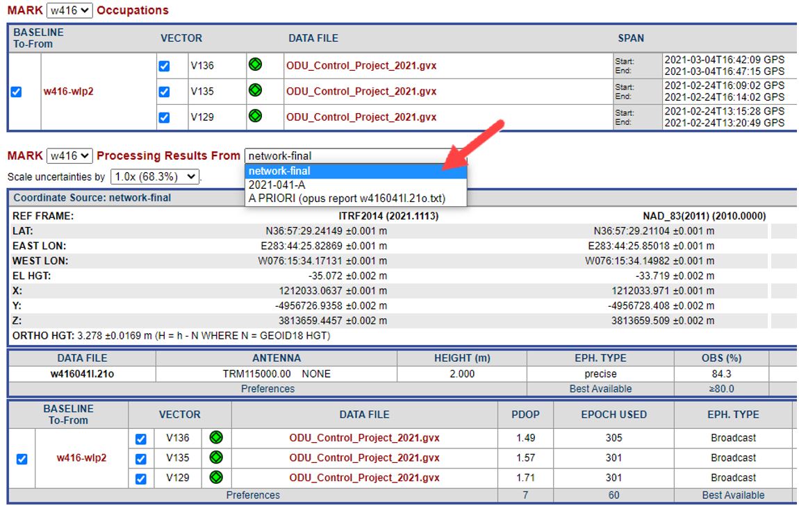
Fig. 12.9 Sample network solution selected from the individual user mark page