Preliminary SPCS2022 Design Maps
NGS is currently in the process of creating preliminary designs for State Plane Coordinate System of 2022 (SPCS2022) zones. These preliminary designs will likely be very close to those eventually adopted by NGS, except in cases where U.S. state and territory stakeholders adopt approved alternative designs.
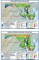
Example of Downloaded Design Maps
Download SPCS2022 Design Maps
Continuously updated SPCS2022 design map images and associated map data are available for download.
The maps show linear distortion at the topographic surface for SPCS2022, along with existing State Plane and Universal Transverse Mercator (UTM) for comparison.
Map data consists of linear distortion rasters and other GIS feature datasets used to create the map.


If zones for your state or territory are not available, please contact the SPCS Team.

