NGS Web Map Instructions
General Map Usage
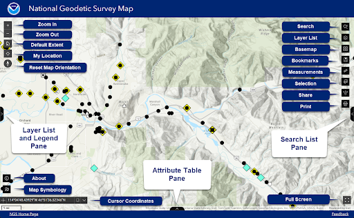
Scrolling a mouse wheel or using the keyboard +/- can be used to zoom in and out. The left click can be used to then pan the map around with the mouse and the up, down, left and right keyboard keys can also be used to pan around the map. There are many widgets highlighted in the image above that will be described in more detail below.
Zoom In, Zoom Out and Default Extent
The + will zoom the map in, the - will zoom the map out and the default extent button will return the map to the starting map extent.
My Location
This widget will zoom you into your current location. On smart phones and computers it will use your current location but you might need to allow the application to access your location.
Reset Map Orientation
If the map orientation is changed this will reorient this to North justified.
Search Utility
Using the search utility you can search for an address, a location and geographic areas. You can also search for features from the NGS Map layers including:
- Datasheets (PID, Name/Designation)
- National CORS Network (Site ID)
- OPUS Shared Solutions (PID, Name/Designation)
Layer List
This will bring up a list of all layers to display on the map and can turn on and off layers to be viewed on the map. For each layer users can click the three dots to the right to see the layer details, adjust the transparency, adjust the layer visibility range, disable popups, hide labels and view the attribute table.
Basemaps
The basemap widget provides access to the basemap gallery which allows the basemap to be changed.
Bookmarks
The bookmarks widget provides quick access to specific regions that will pan/zoom to the area of interest when clicked. Users can add their own bookmarks that will be stored in the browser cache only for that user for future use until the browser cache is cleared.
Measurements
The measurement tool is for measuring areas or distances on the map, or to get coordinates on the map. Click the widget and select the desired tool and then select the desired units for measurement. Begin clicking on the map to see areas or distance and once done make sure to clear the drawing before closing the tool.
Selection
This widget allows users to select features on the map. It will only select features from layers that are turned on. You can choose to make a selection by rectangle, polygon, circle or lasso that is drawn on the map. After a selection is drawn the select widget will list the number of selected features next to that layer. Once a selection is made you can clear selection or click the four dots next to that layer and choose to; zoom to selection, pan to selection, show on map, show pop-up, add marker, view in table, and export to (JSON, CSV, GeoJSON). Once done make sure to clear your selection before closing the Select widget.
Share
This widget allows you to share a URL of the map where you are viewing. You can also click to share it to many social media locations.
This widget allows you to save a PDF or other image type of the map at the current location. There are parameters you can adjust size, choose to only include the map or include a legend and scale bar which is the default setting.
Full Screen
Make the application take up the whole screen, hit Esc to exit.
Feature Popup Info
When a feature is clicked a popup appears that shows attributes for that feature. If there are more than one feature in the area clicked you can cycle through the features.
Cursor Coordinates
As you move your cursor over the map this provides the latitude and longitude of the location that the cursor is on the map. This can help when looking for features at a specific location. Users can also click the left dots to find a specific coordinate on the map.
About
Provides technical details and basic information about the NGS Map.
Map Symbology
This widget provides extensive details about how the feature attributes were used to determine the symbology. This will allow users to use the same symbology and know what attributes are used to define the specific symbol classes.
Layer List and Legend Pane
This will display the legend for all active layers displayed on the map.
Attribute Table Pane
This will open the attribute tables for layers on the map and a user can select the different layers to view the features and attributes for that layer. By default it has all features for that layer in the table but you can click to Filter by map extent. Users can also click on the Options to filter by attributes, show/hide columns (attributes) and to Export all features to a CSV.
Search List Pane
This will open a pane where you can do a more detailed search for the Datasheets, OPUS Shared Solutions and NOAA CORS Network Layers and then sort by different attributes.

