Southeast Texas Orthometric Heights
Background: Vertical Land Motion along the Gulf Coast
The NGS has long recognized that the earth’s surface moves vertically at a wide variety of different rates, and we know that this issue is particularly pronounced along the Gulf Coast of Louisiana and southeast Texas. This variation in rates of motion became apparent as NGS worked to adjust geodetic leveling lines in the region collected between the 1910s and 2000s. In the 1980s, when creating NAVD 88, NGS adjusted together leveling data collected over the previous 8 decades, including over 800,000 bench marks connected by more than 2.2 million kilometers of geodetic leveling. Over the past 30 years, as new leveling lines were measured, they were tied in and constrained to existing published NAVD 88 heights at either end. When adjusting these new level lines, the old published NAVD 88 heights were held constant. If those marks at either end have experienced vertical motion since their heights were published, then this motion would affect the accuracy of the adjustment and cause the newly adjusted NAVD 88 heights to be less accurate. In areas without new leveling or GPS data submitted to NGS, the NAVD 88 published heights do not account for the land motion.
As a result of analyses performed after Hurricane Katrina on the tidal and geodetic datum discrepancies in Louisiana and the uncertainties introduced by the geographically varying rates of vertical land motion, NGS and the state of Louisiana agreed to keep several geodetically important marks per parish up to date for the purpose of understanding vertical motion in the region. This motion not only affected the heights of published marks, but also allowed NGS to reflect those height changes in various regional geodetic models. However, Texas and NGS did not reach a similar agreement to account for the land motion; instead, they continued the existing policy of publishing orthometric heights on datasheets based on the most recent leveling data available in the NGS database. In much of southeast Texas, the available leveling data is between 20 and 100 years old and the geographic patterns of subsidence over the area are not well understood. The result is great uncertainty in the accuracy of the current published heights.
In 2016, NGS began analysis for GEOID18 and the results uncovered over the following three years confirmed the concern of suspect heights in this area. NGS conducted an extensive analysis of more than 32,000 bench marks where NGS had gravity, leveled heights, and GPS observations (see NOS NGS 72 - GEOID18). By comparing these datasets and computing a residual between the ellipsoid, orthometric, and geoid heights, NGS identified marks with high residuals that were suspected of having moved significantly between the time they were leveled and the time they were observed with GPS. Based on this analysis, only 28 of 7,500 published NAVD 88 marks in southeast Texas met the criteria to be included in GEOID18 (shown by the red bounding box below). NGS suspects that the rest of the marks in this area have been affected by regional subsidence.
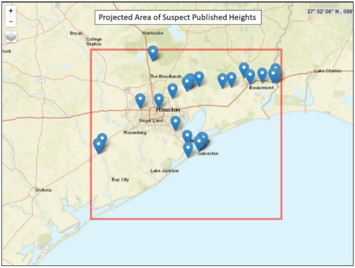
1 Map showing area of flagged marks with suspect published heights and those marks included in the GEOID18 model.
