Moving Mountains: NGS Researchers Reevaluate the Heights of Colorado Mountain Peaks
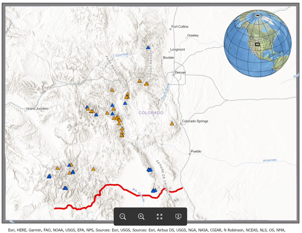
Colorado has more than 50 peaks with summits above 14,000 feet (see Figure 1). Referred to as the “14ers,” these peaks are all slated to become a bit “shorter” in a few years, with the implementation of the new national vertical datum. A new study published in the Journal of Geodesy by a team of researchers at the National Geodetic Survey estimates their new elevations, along with uncertainties on the new values.
The key takeaways from the paper include:
- All of the 14ers have updated estimated elevations and uncertainties. The changes in elevations are due to both:
- the upcoming adoption of a new national geopotential datum
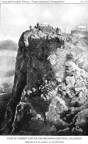
- as well as a re-analysis of the original heights based on classical geodetic surveying techniques (see Figure 2)
- All the 14ers continue to be above the 14,000’ threshold, though there is some “shuffling” in their rankings. No peak is newly ‘elevated’ to the 14er level. Huron Peak, is now the lowest 14er, with an estimated elevation of 14,004.1’ in the new geopotential datum.
- Currently published North American Vertical Datum of 1988 (NAVD 88) elevations on the mountain peak triangulation stations are found to be systematically too high by roughly 1 meter. To investigate and correct this, the team developed a novel technique to redetermine these heights from the historical triangulation data that was measured in the 1950s.
The mountain summit elevations were determined using a combination of two data sources:
- Airborne LiDAR data, acquired via the United States Geological Survey (USGS) 3-D Elevation Program (3DEP) and Colorado Water Conservation Board. These data were used to provide raw ellipsoidal heights.
- A number of available geoid models (i.e. high-resolution models of the Earth’s geopotential field) were used to convert the ellipsoidal heights into orthometric heights (i.e. “heights above sea level”). A combination of these models was used as a proxy for the eventual, “final” model that will serve as the new vertical datum in the National Spatial Reference System (NSRS).
And, for the first time, uncertainty estimates of the summit elevations are also available. These range from about 6 to 8 cm and are determined through a combination of the LiDAR component and the geoid model variability. The uncertainties were independently validated using ground-truthed data from the 2017 Geoid Slope Validation Survey (GSVS17) in southern Colorado (the data points that form the red “line” in Fig.1. van Westrum et al. 2019).
Based on existing nationwide GPS and leveling data, NGS had already calculated estimates of the expected elevation change based solely on the change to the new datum: approximately -60cm throughout Colorado. However, during the course of this study, the authors discovered that the summits were actually appearing to decrease by almost another meter: -160 cm! Further investigation led the team to reevaluate the historical triangulation data that was acquired in the 1950s and originally used to estimate the mountain elevations. The triangulation-based zenith angles were re-analyzed and re-adjusted and found to be too high by about 100 cm. Correcting for this led to much better agreement with the expected datum change estimates. In doing so, the study also independently determined an atmospheric refraction correction term that is in good agreement with results from C.F. Gauss in 1827.
Finally, and of significant importance to the geodesy community, results from this paper highlight the differences in various geoid models including those from global geopotential models (GGMs) such as the Earth Gravitational Model 2008 (EGM2008) (Pavlis et al. 2012). Geoid modeling is inherently difficult in rugged terrain, and the lower resolution GGMs exhibit a pronounced shift from those of higher resolution geoid models over all of the Colorado summits. The GGM-based geoid undulations are systematically too low by 2 to 8 cm depending on the specific model, which would result in heights being too high by the same amount.
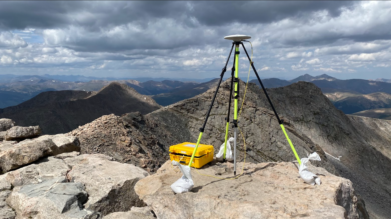
The results of this paper have broad implications for all elevations across the nation with the upcoming modernization of the National Spatial Reference System. The new NSRS will be the foundation for all surveying and mapping in the US going forward. While this paper relies heavily on LiDAR data (due to a lack of dedicated geodetic observations on the peak summits), applications requiring the most precise results will utilize geodetic-grade Global Navigation Satellite System (GNSS) observations along with the new NSRS geopotential datum to determine elevations (as illustrated in the figures below).
Fourteener summit information, sorted by orthometric height. Bold horizontal line delineates the Fourteener cutoff. Note that these values should be taken as preliminary, as a final version of NAPGD2022 has yet to be officially defined. Adapted from Table 7 in Ahlgren et al. 2024.
Name: |
Ellipsoidal height (ITRF2014): [m] |
Geoid undulation: [m] |
Elevation (NAPGD2022* Orthometric Height): [m] |
Estimated Total Uncertainty (1s): [m] |
Elevation (NAPGD2022* Orthometric Height): [feet] |
Mt. Elbert |
4387.17 |
-13.42 |
4400.58 |
±0.064 |
14437.6 |
Mt. Massive |
4383.22 |
-13.20 |
4396.43 |
±0.061 |
14423.9 |
Mt. Harvard |
4381.99 |
-13.75 |
4395.74 |
±0.062 |
14421.7 |
Blanca Peak |
4357.51 |
-15.92 |
4373.43 |
±0.080 |
14348.5 |
La Plata Peak |
4358.12 |
-13.64 |
4371.77 |
±0.068 |
14343.0 |
Uncompahgre Peak |
4348.30 |
-15.15 |
4363.46 |
±0.065 |
14315.8 |
Crestone Peak |
4342.60 |
-15.06 |
4357.66 |
±0.121 |
14296.8 |
Mt. Lincoln |
4342.71 |
-13.09 |
4355.79 |
±0.060 |
14290.6 |
Grays Peak |
4338.52 |
-12.66 |
4351.18 |
±0.061 |
14275.5 |
Castle Peak |
4336.19 |
-14.01 |
4350.20 |
±0.065 |
14272.3 |
Torreys Peak |
4336.87 |
-12.67 |
4349.54 |
±0.061 |
14270.1 |
Quandary Peak |
4336.43 |
-13.05 |
4349.48 |
±0.058 |
14269.9 |
Mt. Antero |
4334.92 |
-14.29 |
4349.21 |
±0.067 |
14269.0 |
Mt. Blue Sky |
4335.66 |
-12.64 |
4348.30 |
±0.068 |
14266.1 |
Longs Peak |
4332.92 |
-12.30 |
4345.22 |
±0.073 |
14255.9 |
Mt. Wilson |
4328.09 |
-16.56 |
4344.64 |
±0.066 |
14254.1 |
Mt. Cameron |
4329.08 |
-13.08 |
4342.16 |
±0.061 |
14245.9 |
Mt. Shavano |
4322.42 |
-14.37 |
4336.79 |
±0.064 |
14228.3 |
Mt. Princeton |
4314.01 |
-14.20 |
4328.21 |
±0.077 |
14200.1 |
Mt. Belford |
4314.32 |
-13.72 |
4328.04 |
±0.065 |
14199.6 |
Mt. Yale |
4313.35 |
-13.89 |
4327.24 |
±0.063 |
14197.0 |
Crestone Needle |
4311.52 |
-15.06 |
4326.58 |
±0.125 |
14194.8 |
Mt. Bross |
4308.35 |
-13.10 |
4321.45 |
±0.060 |
14177.9 |
El Diente Peak |
4303.38 |
-16.60 |
4319.99 |
±0.064 |
14173.2 |
Kit Carson Peak |
4302.50 |
-15.06 |
4317.56 |
±0.113 |
14165.2 |
Maroon Peak |
4302.29 |
-14.13 |
4316.42 |
±0.063 |
14161.5 |
Tabeguache Peak |
4300.72 |
-14.33 |
4315.05 |
±0.067 |
14157.0 |
Mt. Oxford |
4301.13 |
-13.71 |
4314.84 |
±0.062 |
14156.3 |
Mt. Sneffels |
4297.83 |
-16.09 |
4313.93 |
±0.070 |
14153.3 |
Mt. Democrat |
4300.57 |
-13.06 |
4313.64 |
±0.061 |
14152.3 |
Capitol Peak |
4294.51 |
-14.24 |
4308.76 |
±0.060 |
14136.3 |
Pikes Peak |
4284.66 |
-15.17 |
4299.83 |
±0.067 |
14107.0 |
Snowmass Mountain |
4283.98 |
-14.22 |
4298.19 |
±0.060 |
14101.7 |
Windom Peak |
4277.82 |
-15.91 |
4293.72 |
±0.070 |
14087.0 |
Mt. Eolus |
4277.09 |
-16.01 |
4293.11 |
±0.071 |
14085.0 |
Challenger Point |
4277.92 |
-15.07 |
4292.99 |
±0.113 |
14084.6 |
Mt. Columbia |
4275.56 |
-13.79 |
4289.35 |
±0.064 |
14072.6 |
Missouri Mountain |
4274.55 |
-13.74 |
4288.29 |
±0.069 |
14069.2 |
Humboldt Peak |
4272.45 |
-15.05 |
4287.50 |
±0.118 |
14066.6 |
Mt. Bierstadt |
4274.27 |
-12.61 |
4286.88 |
±0.072 |
14064.5 |
Sunlight Peak |
4269.30 |
-15.90 |
4285.20 |
±0.071 |
14059.0 |
Handies Peak |
4268.75 |
-15.49 |
4284.24 |
±0.069 |
14055.9 |
Ellingwood Point |
4268.02 |
-15.92 |
4283.94 |
±0.081 |
14054.9 |
Culebra Peak |
4266.95 |
-16.48 |
4283.43 |
±0.068 |
14053.2 |
Mt. Lindsey |
4267.61 |
-15.82 |
4283.43 |
±0.083 |
14053.2 |
Mt. Sherman |
4266.39 |
-13.13 |
4279.52 |
±0.064 |
14040.4 |
North Eolus |
4263.35 |
-16.00 |
4279.35 |
±0.071 |
14039.8 |
Little Bear Peak |
4263.24 |
-16.00 |
4279.24 |
±0.089 |
14039.5 |
Redcloud Peak |
4262.79 |
-15.39 |
4278.18 |
±0.097 |
14036.0 |
Conundrum Peak |
4263.77 |
-14.01 |
4277.78 |
±0.065 |
14034.7 |
Pyramid Peak |
4261.39 |
-14.09 |
4275.47 |
±0.067 |
14027.1 |
Wilson Peak |
4256.87 |
-16.55 |
4273.42 |
±0.075 |
14020.4 |
San Luis Peak |
4258.23 |
-15.13 |
4273.36 |
±0.071 |
14020.2 |
North Maroon Peak |
4259.16 |
-14.12 |
4273.28 |
±0.063 |
14019.9 |
Wetterhorn Peak |
4257.75 |
-15.22 |
4272.97 |
±0.062 |
14018.9 |
Mt. of the Holy Cross |
4256.15 |
-12.65 |
4268.80 |
±0.060 |
14005.2 |
Sunshine Peak |
4253.17 |
-15.42 |
4268.58 |
±0.075 |
14004.5 |
Huron Peak |
4254.68 |
-13.76 |
4268.45 |
±0.063 |
14004.1 |
|
|
|
|
|
|
Grizzly Peak A |
4252.05 |
-13.59 |
4265.64 |
±0.057 |
13994.9 |
Sunlight Spire |
4249.57 |
-15.90 |
4265.47 |
±0.070 |
13994.3 |
For more information on the 14ers, contact: ngs.infocenter@noaa.gov
