Survey and Related Disciplines
As our country grew westward in the 19th century, surveys were conducted around the nation. To ensure that maps and charts would align with one another, surveyors needed a common reference system.
Following the high standards for accuracy and scientific integrity of the first Survey of the Coast Superintendent Ferdinand Hassler, a national geodetic control network was built.
Today, we manage this network, the National Spatial Reference System, providing a consistent coordinate system for position (latitude and longitude), elevation, distance and direction between points, and how these values change over time.
Read longer descriptions and look at photographs for the the following topics:
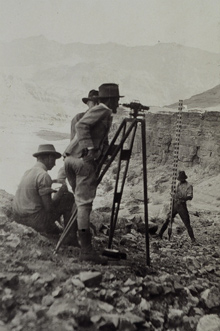
This party is using a Fischer level to leap frog its way into Glen Canyon in 1921.

